You are here: Home > Network List > YN10 - San Jacinto Fault Zone Stations List
> Station TR04 TR04 > Earthquake Result Viewer
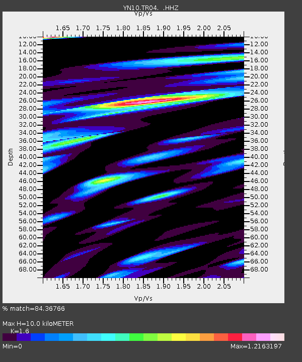
TR04 TR04 - Earthquake Result Viewer
| Earthquake location: |
South Of Kermadec Islands |
| Earthquake latitude/longitude: |
-32.9/-177.9 |
| Earthquake time(UTC): |
2014/02/02 (033) 09:26:37 GMT |
| Earthquake Depth: |
44 km |
| Earthquake Magnitude: |
6.5 MWW, 6.5 MWC, 6.5 MI |
| Earthquake Catalog/Contributor: |
NEIC PDE/NEIC COMCAT |
|
| Network: |
YN San Jacinto Fault Zone |
| Station: |
TR04 TR04 |
| Lat/Lon: |
33.40 N/116.43 W |
| Elevation: |
774 m |
|
| Distance: |
87.7 deg |
| Az: |
47.345 deg |
| Baz: |
227.692 deg |
| Ray Param: |
0.043060448 |
| Estimated Moho Depth: |
10.0 km |
| Estimated Crust Vp/Vs: |
1.60 |
| Assumed Crust Vp: |
6.264 km/s |
| Estimated Crust Vs: |
3.915 km/s |
| Estimated Crust Poisson's Ratio: |
0.18 |
|
| Radial Match: |
84.36766 % |
| Radial Bump: |
400 |
| Transverse Match: |
80.94884 % |
| Transverse Bump: |
400 |
| SOD ConfigId: |
626651 |
| Insert Time: |
2014-04-20 14:24:15.878 +0000 |
| GWidth: |
2.5 |
| Max Bumps: |
400 |
| Tol: |
0.001 |
|

Signal To Noise
| Channel | StoN | STA | LTA |
| YN:TR04: :HHZ:20140202T09:38:50.593987Z | 5.5720916 | 1.5285494E-6 | 2.743224E-7 |
| YN:TR04: :HHN:20140202T09:38:50.593987Z | 1.6319427 | 6.1885294E-7 | 3.792124E-7 |
| YN:TR04: :HHE:20140202T09:38:50.593987Z | 1.307666 | 4.0012927E-7 | 3.0598738E-7 |
| Arrivals |
| Ps | 1.0 SECOND |
| PpPs | 4.1 SECOND |
| PsPs/PpSs | 5.0 SECOND |


