You are here: Home > Network List > GT - Global Telemetered Seismograph Network (USAF/USGS) Stations List
> Station CPUP Villa Florida, Paraguay > Earthquake Result Viewer
CPUP Villa Florida, Paraguay - Earthquake Result Viewer

| Earthquake location: |
South Sandwich Islands Region |
| Earthquake latitude/longitude: |
-56.6/-24.8 |
| Earthquake time(UTC): |
2014/12/29 (363) 17:41:47 GMT |
| Earthquake Depth: |
10 km |
| Earthquake Magnitude: |
5.6 MWB |
| Earthquake Catalog/Contributor: |
NEIC PDE/NEIC COMCAT |
|
| Network: |
GT Global Telemetered Seismograph Network (USAF/USGS) |
| Station: |
CPUP Villa Florida, Paraguay |
| Lat/Lon: |
26.33 S/57.33 W |
| Elevation: |
105 m |
|
| Distance: |
38.2 deg |
| Az: |
308.708 deg |
| Baz: |
151.275 deg |
| Ray Param: |
0.07569915 |
| Estimated Moho Depth: |
37.0 km |
| Estimated Crust Vp/Vs: |
1.67 |
| Assumed Crust Vp: |
6.498 km/s |
| Estimated Crust Vs: |
3.897 km/s |
| Estimated Crust Poisson's Ratio: |
0.22 |
|
| Radial Match: |
84.85348 % |
| Radial Bump: |
369 |
| Transverse Match: |
78.423805 % |
| Transverse Bump: |
400 |
| SOD ConfigId: |
3390531 |
| Insert Time: |
2019-04-15 20:27:31.438 +0000 |
| GWidth: |
2.5 |
| Max Bumps: |
400 |
| Tol: |
0.001 |
|
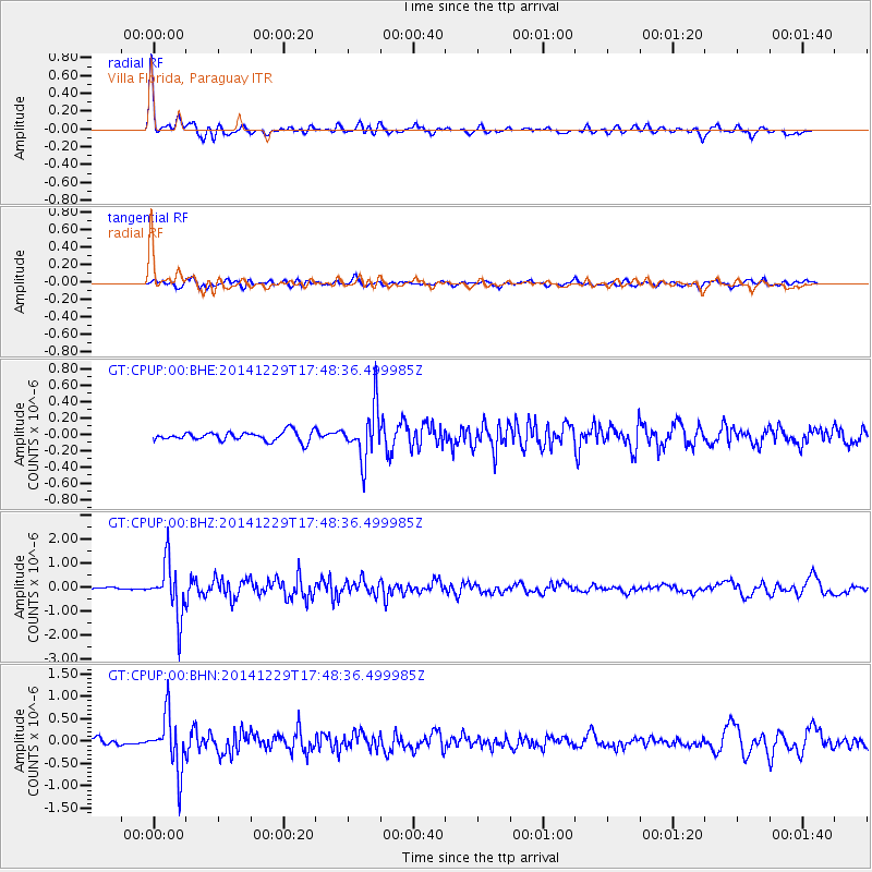
Signal To Noise
| Channel | StoN | STA | LTA |
| GT:CPUP:00:BHZ:20141229T17:48:36.499985Z | 14.734533 | 1.1014173E-6 | 7.475074E-8 |
| GT:CPUP:00:BHN:20141229T17:48:36.499985Z | 9.294612 | 6.1276825E-7 | 6.592725E-8 |
| GT:CPUP:00:BHE:20141229T17:48:36.499985Z | 5.4902706 | 3.1615386E-7 | 5.7584383E-8 |
| Arrivals |
| Ps | 4.1 SECOND |
| PpPs | 14 SECOND |
| PsPs/PpSs | 18 SECOND |


