You are here: Home > Network List > TA - USArray Transportable Network (new EarthScope stations) Stations List
> Station J46A Howard City, MI, USA > Earthquake Result Viewer
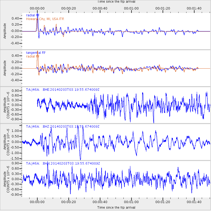
J46A Howard City, MI, USA - Earthquake Result Viewer
*The percent match for this event was below the threshold and hence no stack was calculated.
| Earthquake location: |
Greece |
| Earthquake latitude/longitude: |
38.3/20.4 |
| Earthquake time(UTC): |
2014/02/03 (034) 03:08:46 GMT |
| Earthquake Depth: |
5.0 km |
| Earthquake Magnitude: |
6.0 MWW, 6.0 MWB, 6.1 MWC |
| Earthquake Catalog/Contributor: |
NEIC PDE/NEIC COMCAT |
|
| Network: |
TA USArray Transportable Network (new EarthScope stations) |
| Station: |
J46A Howard City, MI, USA |
| Lat/Lon: |
43.35 N/85.65 W |
| Elevation: |
275 m |
|
| Distance: |
74.7 deg |
| Az: |
313.387 deg |
| Baz: |
51.647 deg |
| Ray Param: |
$rayparam |
*The percent match for this event was below the threshold and hence was not used in the summary stack. |
|
| Radial Match: |
70.93935 % |
| Radial Bump: |
400 |
| Transverse Match: |
58.80779 % |
| Transverse Bump: |
400 |
| SOD ConfigId: |
626651 |
| Insert Time: |
2014-04-20 14:45:15.149 +0000 |
| GWidth: |
2.5 |
| Max Bumps: |
400 |
| Tol: |
0.001 |
|
Signal To Noise
| Channel | StoN | STA | LTA |
| TA:J46A: :BHZ:20140203T03:19:55.674009Z | 2.3844657 | 3.6632133E-7 | 1.5362826E-7 |
| TA:J46A: :BHN:20140203T03:19:55.674009Z | 0.79769665 | 1.5929442E-7 | 1.9969298E-7 |
| TA:J46A: :BHE:20140203T03:19:55.674009Z | 0.91594356 | 1.725763E-7 | 1.884137E-7 |
| Arrivals |
| Ps | |
| PpPs | |
| PsPs/PpSs | |


