You are here: Home > Network List > TA - USArray Transportable Network (new EarthScope stations) Stations List
> Station J47A Sunmer, MI, USA > Earthquake Result Viewer
J47A Sunmer, MI, USA - Earthquake Result Viewer
| Earthquake location: |
Greece |
| Earthquake latitude/longitude: |
38.3/20.4 |
| Earthquake time(UTC): |
2014/02/03 (034) 03:08:46 GMT |
| Earthquake Depth: |
5.0 km |
| Earthquake Magnitude: |
6.0 MWW, 6.0 MWB, 6.1 MWC |
| Earthquake Catalog/Contributor: |
NEIC PDE/NEIC COMCAT |
|
| Network: |
TA USArray Transportable Network (new EarthScope stations) |
| Station: |
J47A Sunmer, MI, USA |
| Lat/Lon: |
43.24 N/84.82 W |
| Elevation: |
236 m |
|
| Distance: |
74.3 deg |
| Az: |
312.911 deg |
| Baz: |
52.084 deg |
| Ray Param: |
0.052412864 |
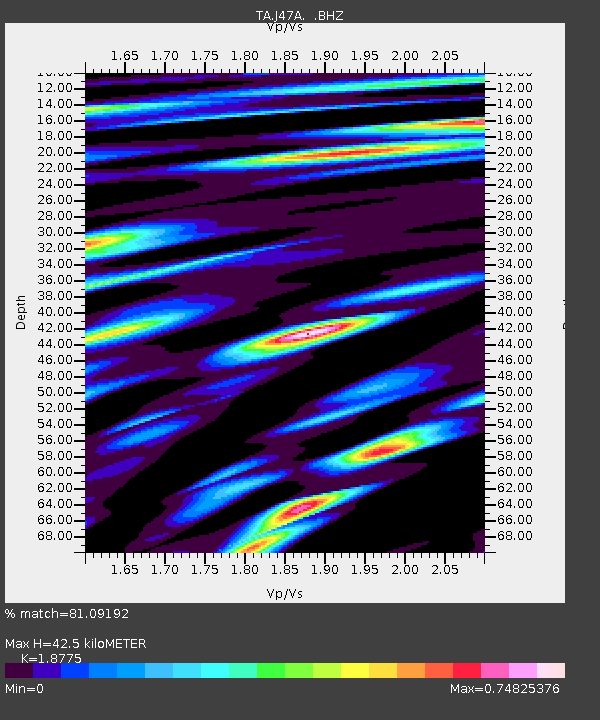
| Estimated Moho Depth: |
42.5 km |
| Estimated Crust Vp/Vs: |
1.88 |
| Assumed Crust Vp: |
6.483 km/s |
| Estimated Crust Vs: |
3.453 km/s |
| Estimated Crust Poisson's Ratio: |
0.30 |
|
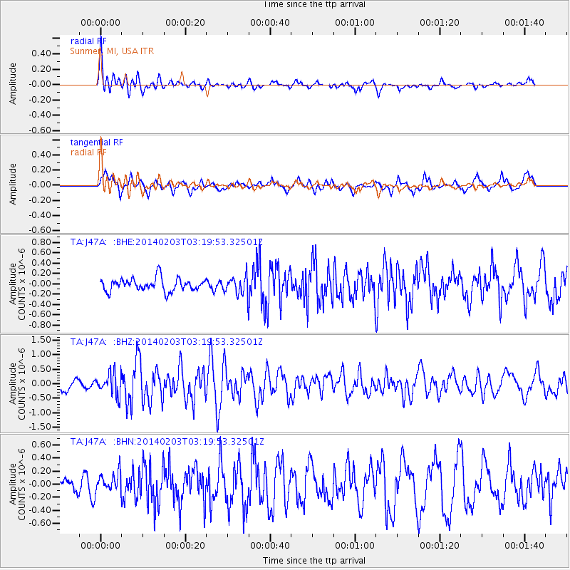
| Radial Match: |
81.09192 % |
| Radial Bump: |
400 |
| Transverse Match: |
56.551643 % |
| Transverse Bump: |
400 |
| SOD ConfigId: |
626651 |
| Insert Time: |
2014-04-20 14:45:16.027 +0000 |
| GWidth: |
2.5 |
| Max Bumps: |
400 |
| Tol: |
0.001 |
|
Signal To Noise
| Channel | StoN | STA | LTA |
| TA:J47A: :BHZ:20140203T03:19:53.32501Z | 1.923301 | 3.8175548E-7 | 1.9848973E-7 |
| TA:J47A: :BHN:20140203T03:19:53.32501Z | 0.97874063 | 1.5063151E-7 | 1.5390339E-7 |
| TA:J47A: :BHE:20140203T03:19:53.32501Z | 1.4211692 | 1.7411001E-7 | 1.2251182E-7 |
| Arrivals |
| Ps | 5.9 SECOND |
| PpPs | 18 SECOND |
| PsPs/PpSs | 24 SECOND |


