You are here: Home > Network List > TA - USArray Transportable Network (new EarthScope stations) Stations List
> Station L48A N Adams, MI, USA > Earthquake Result Viewer
L48A N Adams, MI, USA - Earthquake Result Viewer
| Earthquake location: |
Greece |
| Earthquake latitude/longitude: |
38.3/20.4 |
| Earthquake time(UTC): |
2014/02/03 (034) 03:08:46 GMT |
| Earthquake Depth: |
5.0 km |
| Earthquake Magnitude: |
6.0 MWW, 6.0 MWB, 6.1 MWC |
| Earthquake Catalog/Contributor: |
NEIC PDE/NEIC COMCAT |
|
| Network: |
TA USArray Transportable Network (new EarthScope stations) |
| Station: |
L48A N Adams, MI, USA |
| Lat/Lon: |
41.94 N/84.43 W |
| Elevation: |
369 m |
|
| Distance: |
74.9 deg |
| Az: |
311.67 deg |
| Baz: |
52.017 deg |
| Ray Param: |
0.05203002 |
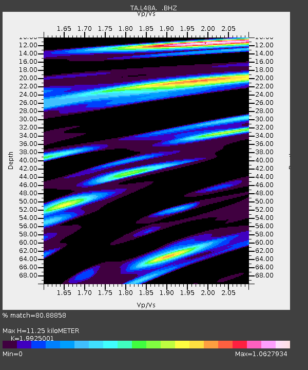
| Estimated Moho Depth: |
11.25 km |
| Estimated Crust Vp/Vs: |
1.99 |
| Assumed Crust Vp: |
6.498 km/s |
| Estimated Crust Vs: |
3.261 km/s |
| Estimated Crust Poisson's Ratio: |
0.33 |
|
| Radial Match: |
80.88858 % |
| Radial Bump: |
400 |
| Transverse Match: |
55.525936 % |
| Transverse Bump: |
400 |
| SOD ConfigId: |
626651 |
| Insert Time: |
2014-04-20 14:46:12.454 +0000 |
| GWidth: |
2.5 |
| Max Bumps: |
400 |
| Tol: |
0.001 |
|
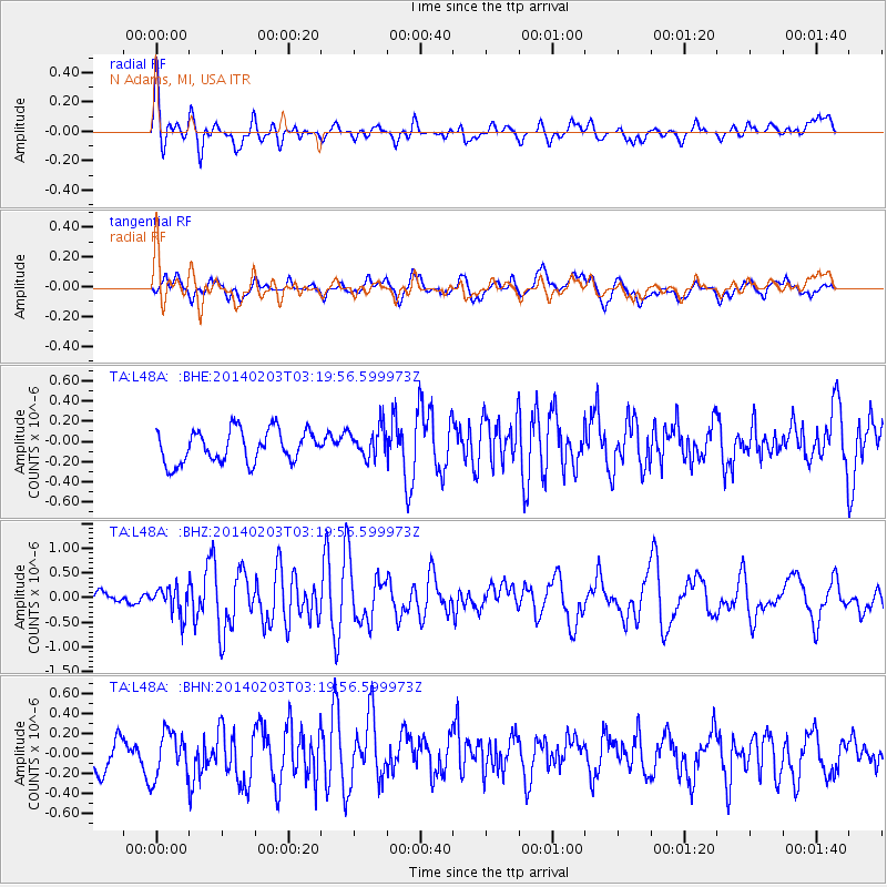
Signal To Noise
| Channel | StoN | STA | LTA |
| TA:L48A: :BHZ:20140203T03:19:56.599973Z | 1.8775827 | 2.8656612E-7 | 1.5262503E-7 |
| TA:L48A: :BHN:20140203T03:19:56.599973Z | 1.3350368 | 2.2619629E-7 | 1.6943075E-7 |
| TA:L48A: :BHE:20140203T03:19:56.599973Z | 0.9747057 | 1.5494335E-7 | 1.5896426E-7 |
| Arrivals |
| Ps | 1.8 SECOND |
| PpPs | 5.0 SECOND |
| PsPs/PpSs | 6.8 SECOND |


