You are here: Home > Network List > TA - USArray Transportable Network (new EarthScope stations) Stations List
> Station M53A WI Miller and Sons, Farmdale, OH, USA > Earthquake Result Viewer
M53A WI Miller and Sons, Farmdale, OH, USA - Earthquake Result Viewer
| Earthquake location: |
Greece |
| Earthquake latitude/longitude: |
38.3/20.4 |
| Earthquake time(UTC): |
2014/02/03 (034) 03:08:46 GMT |
| Earthquake Depth: |
5.0 km |
| Earthquake Magnitude: |
6.0 MWW, 6.0 MWB, 6.1 MWC |
| Earthquake Catalog/Contributor: |
NEIC PDE/NEIC COMCAT |
|
| Network: |
TA USArray Transportable Network (new EarthScope stations) |
| Station: |
M53A WI Miller and Sons, Farmdale, OH, USA |
| Lat/Lon: |
41.44 N/80.68 W |
| Elevation: |
334 m |
|
| Distance: |
73.0 deg |
| Az: |
309.488 deg |
| Baz: |
53.903 deg |
| Ray Param: |
0.053327166 |
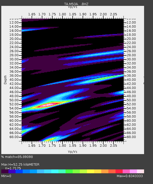
| Estimated Moho Depth: |
52.25 km |
| Estimated Crust Vp/Vs: |
1.72 |
| Assumed Crust Vp: |
6.483 km/s |
| Estimated Crust Vs: |
3.774 km/s |
| Estimated Crust Poisson's Ratio: |
0.24 |
|
| Radial Match: |
85.89098 % |
| Radial Bump: |
400 |
| Transverse Match: |
59.7016 % |
| Transverse Bump: |
400 |
| SOD ConfigId: |
626651 |
| Insert Time: |
2014-04-20 14:46:43.388 +0000 |
| GWidth: |
2.5 |
| Max Bumps: |
400 |
| Tol: |
0.001 |
|

Signal To Noise
| Channel | StoN | STA | LTA |
| TA:M53A: :BHZ:20140203T03:19:45.249998Z | 1.628356 | 2.8560657E-7 | 1.7539566E-7 |
| TA:M53A: :BHN:20140203T03:19:45.249998Z | 0.85985535 | 1.4171393E-7 | 1.6481135E-7 |
| TA:M53A: :BHE:20140203T03:19:45.249998Z | 0.71479887 | 1.08038144E-7 | 1.5114482E-7 |
| Arrivals |
| Ps | 6.0 SECOND |
| PpPs | 21 SECOND |
| PsPs/PpSs | 27 SECOND |


