You are here: Home > Network List > TA - USArray Transportable Network (new EarthScope stations) Stations List
> Station N50A Nevada, OH, USA > Earthquake Result Viewer
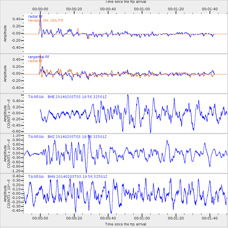
N50A Nevada, OH, USA - Earthquake Result Viewer
*The percent match for this event was below the threshold and hence no stack was calculated.
| Earthquake location: |
Greece |
| Earthquake latitude/longitude: |
38.3/20.4 |
| Earthquake time(UTC): |
2014/02/03 (034) 03:08:46 GMT |
| Earthquake Depth: |
5.0 km |
| Earthquake Magnitude: |
6.0 MWW, 6.0 MWB, 6.1 MWC |
| Earthquake Catalog/Contributor: |
NEIC PDE/NEIC COMCAT |
|
| Network: |
TA USArray Transportable Network (new EarthScope stations) |
| Station: |
N50A Nevada, OH, USA |
| Lat/Lon: |
40.77 N/83.15 W |
| Elevation: |
277 m |
|
| Distance: |
74.9 deg |
| Az: |
310.098 deg |
| Baz: |
52.452 deg |
| Ray Param: |
$rayparam |
*The percent match for this event was below the threshold and hence was not used in the summary stack. |
|
| Radial Match: |
77.31087 % |
| Radial Bump: |
400 |
| Transverse Match: |
66.58432 % |
| Transverse Bump: |
380 |
| SOD ConfigId: |
626651 |
| Insert Time: |
2014-04-20 14:47:23.613 +0000 |
| GWidth: |
2.5 |
| Max Bumps: |
400 |
| Tol: |
0.001 |
|
Signal To Noise
| Channel | StoN | STA | LTA |
| TA:N50A: :BHZ:20140203T03:19:56.32501Z | 2.452809 | 2.5469203E-7 | 1.0383687E-7 |
| TA:N50A: :BHN:20140203T03:19:56.32501Z | 0.8293004 | 1.1491545E-7 | 1.3856915E-7 |
| TA:N50A: :BHE:20140203T03:19:56.32501Z | 2.1408558 | 1.9194219E-7 | 8.965676E-8 |
| Arrivals |
| Ps | |
| PpPs | |
| PsPs/PpSs | |


