You are here: Home > Network List > TA - USArray Transportable Network (new EarthScope stations) Stations List
> Station R60A Leonardtown, MD, USA > Earthquake Result Viewer
R60A Leonardtown, MD, USA - Earthquake Result Viewer

| Earthquake location: |
Greece |
| Earthquake latitude/longitude: |
38.3/20.4 |
| Earthquake time(UTC): |
2014/02/03 (034) 03:08:46 GMT |
| Earthquake Depth: |
5.0 km |
| Earthquake Magnitude: |
6.0 MWW, 6.0 MWB, 6.1 MWC |
| Earthquake Catalog/Contributor: |
NEIC PDE/NEIC COMCAT |
|
| Network: |
TA USArray Transportable Network (new EarthScope stations) |
| Station: |
R60A Leonardtown, MD, USA |
| Lat/Lon: |
38.26 N/76.58 W |
| Elevation: |
33 m |
|
| Distance: |
72.2 deg |
| Az: |
304.865 deg |
| Baz: |
55.135 deg |
| Ray Param: |
0.053806536 |
| Estimated Moho Depth: |
45.0 km |
| Estimated Crust Vp/Vs: |
1.60 |
| Assumed Crust Vp: |
6.419 km/s |
| Estimated Crust Vs: |
4.006 km/s |
| Estimated Crust Poisson's Ratio: |
0.18 |
|
| Radial Match: |
82.62872 % |
| Radial Bump: |
400 |
| Transverse Match: |
60.8073 % |
| Transverse Bump: |
400 |
| SOD ConfigId: |
626651 |
| Insert Time: |
2014-04-20 14:49:14.613 +0000 |
| GWidth: |
2.5 |
| Max Bumps: |
400 |
| Tol: |
0.001 |
|
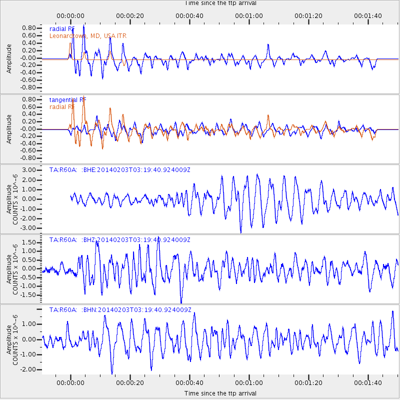
Signal To Noise
| Channel | StoN | STA | LTA |
| TA:R60A: :BHZ:20140203T03:19:40.924009Z | 2.0715253 | 4.698779E-7 | 2.2682701E-7 |
| TA:R60A: :BHN:20140203T03:19:40.924009Z | 0.87121636 | 3.9174213E-7 | 4.496497E-7 |
| TA:R60A: :BHE:20140203T03:19:40.924009Z | 1.0339186 | 3.8507122E-7 | 3.7243862E-7 |
| Arrivals |
| Ps | 4.4 SECOND |
| PpPs | 18 SECOND |
| PsPs/PpSs | 22 SECOND |


