You are here: Home > Network List > UU - University of Utah Regional Network Stations List
> Station BSUT Blindstream Canyon, Hanna, UT, USA > Earthquake Result Viewer
BSUT Blindstream Canyon, Hanna, UT, USA - Earthquake Result Viewer
| Earthquake location: |
Greece |
| Earthquake latitude/longitude: |
38.3/20.4 |
| Earthquake time(UTC): |
2014/02/03 (034) 03:08:46 GMT |
| Earthquake Depth: |
5.0 km |
| Earthquake Magnitude: |
6.0 MWW, 6.0 MWB, 6.1 MWC |
| Earthquake Catalog/Contributor: |
NEIC PDE/NEIC COMCAT |
|
| Network: |
UU University of Utah Regional Network |
| Station: |
BSUT Blindstream Canyon, Hanna, UT, USA |
| Lat/Lon: |
40.54 N/110.76 W |
| Elevation: |
3211 m |
|
| Distance: |
89.7 deg |
| Az: |
324.979 deg |
| Baz: |
36.352 deg |
| Ray Param: |
0.041723702 |
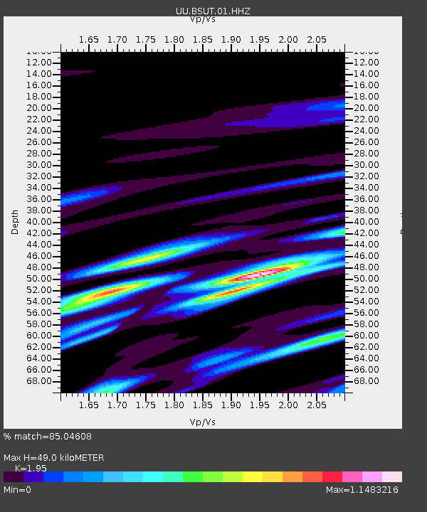
| Estimated Moho Depth: |
49.0 km |
| Estimated Crust Vp/Vs: |
1.95 |
| Assumed Crust Vp: |
6.155 km/s |
| Estimated Crust Vs: |
3.156 km/s |
| Estimated Crust Poisson's Ratio: |
0.32 |
|
| Radial Match: |
85.04608 % |
| Radial Bump: |
400 |
| Transverse Match: |
32.725983 % |
| Transverse Bump: |
366 |
| SOD ConfigId: |
626651 |
| Insert Time: |
2014-04-20 14:53:35.204 +0000 |
| GWidth: |
2.5 |
| Max Bumps: |
400 |
| Tol: |
0.001 |
|

Signal To Noise
| Channel | StoN | STA | LTA |
| UU:BSUT:01:HHZ:20140203T03:21:13.85803Z | 2.1500683 | 1.548961E-8 | 7.2042408E-9 |
| UU:BSUT:01:HHN:20140203T03:21:13.85803Z | 0.5694615 | 5.8679457E-9 | 1.0304375E-8 |
| UU:BSUT:01:HHE:20140203T03:21:13.85803Z | 0.8371689 | 6.8372836E-9 | 8.16715E-9 |
| Arrivals |
| Ps | 7.7 SECOND |
| PpPs | 23 SECOND |
| PsPs/PpSs | 31 SECOND |


