You are here: Home > Network List > CB - China National Seismic Network Stations List
> Station GTA Gaotai,Gansu Province > Earthquake Result Viewer
GTA Gaotai,Gansu Province - Earthquake Result Viewer
| Earthquake location: |
Banda Sea |
| Earthquake latitude/longitude: |
-7.2/128.2 |
| Earthquake time(UTC): |
2014/02/03 (034) 22:36:37 GMT |
| Earthquake Depth: |
7.1 km |
| Earthquake Magnitude: |
5.8 MWW, 5.8 MWB, 5.9 MWC |
| Earthquake Catalog/Contributor: |
NEIC PDE/NEIC COMCAT |
|
| Network: |
CB China National Seismic Network |
| Station: |
GTA Gaotai,Gansu Province |
| Lat/Lon: |
39.40 N/99.82 E |
| Elevation: |
1345 m |
|
| Distance: |
53.3 deg |
| Az: |
332.671 deg |
| Baz: |
143.99 deg |
| Ray Param: |
0.06621517 |
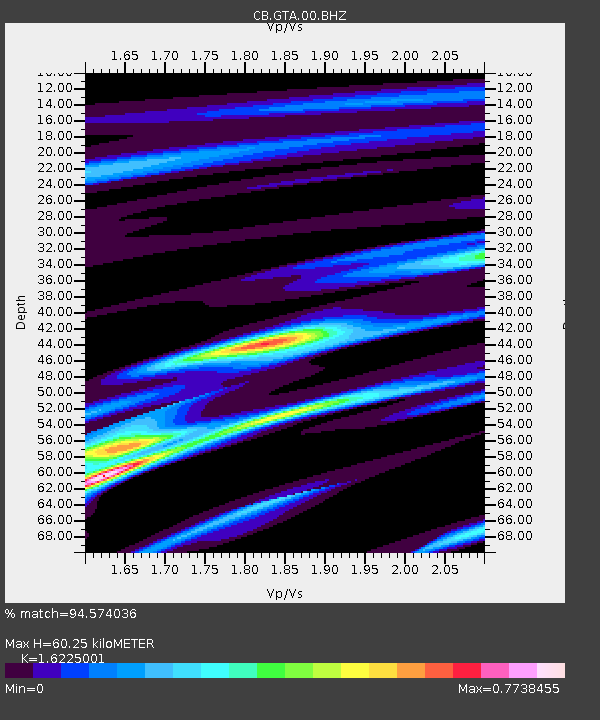
| Estimated Moho Depth: |
60.25 km |
| Estimated Crust Vp/Vs: |
1.62 |
| Assumed Crust Vp: |
6.491 km/s |
| Estimated Crust Vs: |
4.001 km/s |
| Estimated Crust Poisson's Ratio: |
0.19 |
|
| Radial Match: |
94.574036 % |
| Radial Bump: |
312 |
| Transverse Match: |
88.341835 % |
| Transverse Bump: |
400 |
| SOD ConfigId: |
626651 |
| Insert Time: |
2014-04-20 15:12:13.400 +0000 |
| GWidth: |
2.5 |
| Max Bumps: |
400 |
| Tol: |
0.001 |
|

Signal To Noise
| Channel | StoN | STA | LTA |
| CB:GTA:00:BHZ:20140203T22:45:25.379978Z | 9.6571455 | 2.76944E-7 | 2.8677627E-8 |
| CB:GTA:00:BHN:20140203T22:45:25.379978Z | 3.2903714 | 8.580024E-8 | 2.6076155E-8 |
| CB:GTA:00:BHE:20140203T22:45:25.379978Z | 1.7584862 | 8.202139E-8 | 4.6643184E-8 |
| Arrivals |
| Ps | 6.1 SECOND |
| PpPs | 23 SECOND |
| PsPs/PpSs | 29 SECOND |


