You are here: Home > Network List > CB - China National Seismic Network Stations List
> Station HEH Heihe,Heilongjiang Province > Earthquake Result Viewer
HEH Heihe,Heilongjiang Province - Earthquake Result Viewer
| Earthquake location: |
Banda Sea |
| Earthquake latitude/longitude: |
-7.2/128.2 |
| Earthquake time(UTC): |
2014/02/03 (034) 22:36:37 GMT |
| Earthquake Depth: |
7.1 km |
| Earthquake Magnitude: |
5.8 MWW, 5.8 MWB, 5.9 MWC |
| Earthquake Catalog/Contributor: |
NEIC PDE/NEIC COMCAT |
|
| Network: |
CB China National Seismic Network |
| Station: |
HEH Heihe,Heilongjiang Province |
| Lat/Lon: |
50.25 N/127.41 E |
| Elevation: |
165 m |
|
| Distance: |
57.2 deg |
| Az: |
359.418 deg |
| Baz: |
179.101 deg |
| Ray Param: |
0.06364162 |
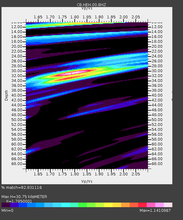
| Estimated Moho Depth: |
30.75 km |
| Estimated Crust Vp/Vs: |
1.79 |
| Assumed Crust Vp: |
6.419 km/s |
| Estimated Crust Vs: |
3.596 km/s |
| Estimated Crust Poisson's Ratio: |
0.27 |
|
| Radial Match: |
92.831116 % |
| Radial Bump: |
333 |
| Transverse Match: |
70.160416 % |
| Transverse Bump: |
400 |
| SOD ConfigId: |
626651 |
| Insert Time: |
2014-04-20 15:12:18.183 +0000 |
| GWidth: |
2.5 |
| Max Bumps: |
400 |
| Tol: |
0.001 |
|

Signal To Noise
| Channel | StoN | STA | LTA |
| CB:HEH:00:BHZ:20140203T22:45:53.709995Z | 8.424055 | 1.1360895E-6 | 1.3486255E-7 |
| CB:HEH:00:BHN:20140203T22:45:53.709995Z | 6.1781044 | 5.0950445E-7 | 8.2469384E-8 |
| CB:HEH:00:BHE:20140203T22:45:53.709995Z | 0.7077634 | 8.6091944E-8 | 1.2163945E-7 |
| Arrivals |
| Ps | 4.0 SECOND |
| PpPs | 13 SECOND |
| PsPs/PpSs | 17 SECOND |


