You are here: Home > Network List > IU - Global Seismograph Network (GSN - IRIS/USGS) Stations List
> Station PMG Port Moresby, New Guinea > Earthquake Result Viewer
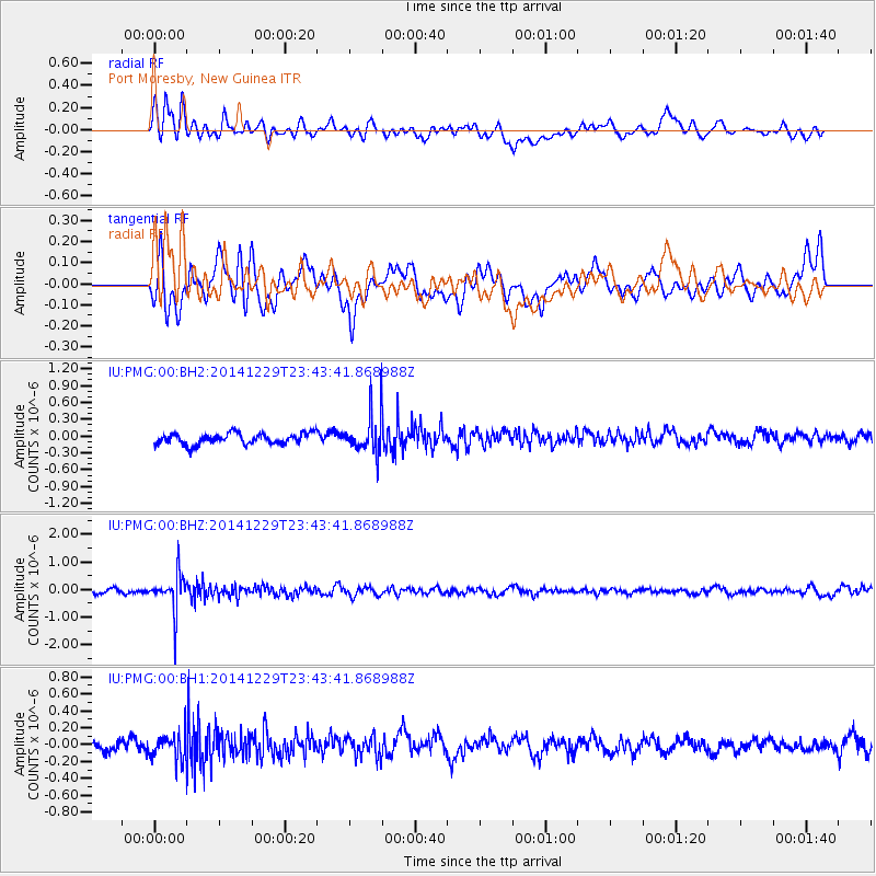
PMG Port Moresby, New Guinea - Earthquake Result Viewer
*The percent match for this event was below the threshold and hence no stack was calculated.
| Earthquake location: |
Fiji Islands Region |
| Earthquake latitude/longitude: |
-20.7/-177.6 |
| Earthquake time(UTC): |
2014/12/29 (363) 23:37:56 GMT |
| Earthquake Depth: |
495 km |
| Earthquake Magnitude: |
5.3 MW, 5.1 mb, 5.0 mB |
| Earthquake Catalog/Contributor: |
ISC/ISC |
|
| Network: |
IU Global Seismograph Network (GSN - IRIS/USGS) |
| Station: |
PMG Port Moresby, New Guinea |
| Lat/Lon: |
9.40 S/147.16 E |
| Elevation: |
90 m |
|
| Distance: |
35.8 deg |
| Az: |
282.977 deg |
| Baz: |
112.395 deg |
| Ray Param: |
$rayparam |
*The percent match for this event was below the threshold and hence was not used in the summary stack. |
|
| Radial Match: |
51.99774 % |
| Radial Bump: |
400 |
| Transverse Match: |
58.32607 % |
| Transverse Bump: |
400 |
| SOD ConfigId: |
3390531 |
| Insert Time: |
2019-04-15 20:41:22.171 +0000 |
| GWidth: |
2.5 |
| Max Bumps: |
400 |
| Tol: |
0.001 |
|
Signal To Noise
| Channel | StoN | STA | LTA |
| IU:PMG:00:BHZ:20141229T23:43:41.868988Z | 6.1774006 | 6.371242E-7 | 1.031379E-7 |
| IU:PMG:00:BH1:20141229T23:43:41.868988Z | 1.4912784 | 1.5443352E-7 | 1.0355781E-7 |
| IU:PMG:00:BH2:20141229T23:43:41.868988Z | 3.4614625 | 3.3573542E-7 | 9.699236E-8 |
| Arrivals |
| Ps | |
| PpPs | |
| PsPs/PpSs | |


