You are here: Home > Network List > IU - Global Seismograph Network (GSN - IRIS/USGS) Stations List
> Station JOHN Johnston Island, USA > Earthquake Result Viewer
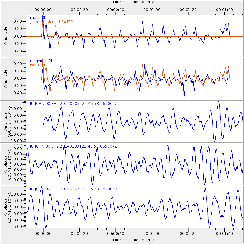
JOHN Johnston Island, USA - Earthquake Result Viewer
*The percent match for this event was below the threshold and hence no stack was calculated.
| Earthquake location: |
Banda Sea |
| Earthquake latitude/longitude: |
-7.2/128.2 |
| Earthquake time(UTC): |
2014/02/03 (034) 22:36:37 GMT |
| Earthquake Depth: |
7.1 km |
| Earthquake Magnitude: |
5.8 MWW, 5.8 MWB, 5.9 MWC |
| Earthquake Catalog/Contributor: |
NEIC PDE/NEIC COMCAT |
|
| Network: |
IU Global Seismograph Network (GSN - IRIS/USGS) |
| Station: |
JOHN Johnston Island, USA |
| Lat/Lon: |
16.73 N/169.53 W |
| Elevation: |
2.0 m |
|
| Distance: |
66.0 deg |
| Az: |
68.201 deg |
| Baz: |
254.046 deg |
| Ray Param: |
$rayparam |
*The percent match for this event was below the threshold and hence was not used in the summary stack. |
|
| Radial Match: |
58.596718 % |
| Radial Bump: |
400 |
| Transverse Match: |
52.52912 % |
| Transverse Bump: |
398 |
| SOD ConfigId: |
626651 |
| Insert Time: |
2014-04-20 15:14:52.763 +0000 |
| GWidth: |
2.5 |
| Max Bumps: |
400 |
| Tol: |
0.001 |
|
Signal To Noise
| Channel | StoN | STA | LTA |
| IU:JOHN:00:BHZ:20140203T22:46:53.069004Z | 0.28632542 | 1.3736102E-6 | 4.797374E-6 |
| IU:JOHN:00:BH1:20140203T22:46:53.069004Z | 2.9875126 | 1.0558683E-5 | 3.5342723E-6 |
| IU:JOHN:00:BH2:20140203T22:46:53.069004Z | 0.7938186 | 4.7327726E-6 | 5.962033E-6 |
| Arrivals |
| Ps | |
| PpPs | |
| PsPs/PpSs | |


