You are here: Home > Network List > GT - Global Telemetered Seismograph Network (USAF/USGS) Stations List
> Station LPAZ La Paz , Bolivia > Earthquake Result Viewer
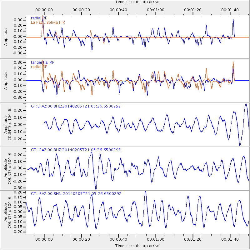
LPAZ La Paz , Bolivia - Earthquake Result Viewer
*The percent match for this event was below the threshold and hence no stack was calculated.
| Earthquake location: |
Balleny Islands Region |
| Earthquake latitude/longitude: |
-61.4/154.5 |
| Earthquake time(UTC): |
2014/02/05 (036) 20:52:33 GMT |
| Earthquake Depth: |
10 km |
| Earthquake Magnitude: |
5.9 MWW, 5.8 MWB, 5.9 MWC |
| Earthquake Catalog/Contributor: |
NEIC PDE/NEIC COMCAT |
|
| Network: |
GT Global Telemetered Seismograph Network (USAF/USGS) |
| Station: |
LPAZ La Paz , Bolivia |
| Lat/Lon: |
16.17 S/68.08 W |
| Elevation: |
4817 m |
|
| Distance: |
95.6 deg |
| Az: |
139.251 deg |
| Baz: |
199.082 deg |
| Ray Param: |
$rayparam |
*The percent match for this event was below the threshold and hence was not used in the summary stack. |
|
| Radial Match: |
57.2838 % |
| Radial Bump: |
400 |
| Transverse Match: |
51.418446 % |
| Transverse Bump: |
400 |
| SOD ConfigId: |
626651 |
| Insert Time: |
2014-04-20 15:18:53.279 +0000 |
| GWidth: |
2.5 |
| Max Bumps: |
400 |
| Tol: |
0.001 |
|
Signal To Noise
| Channel | StoN | STA | LTA |
| GT:LPAZ:00:BHZ:20140205T21:05:26.650029Z | 0.87973744 | 9.0551794E-8 | 1.0293048E-7 |
| GT:LPAZ:00:BHN:20140205T21:05:26.650029Z | 0.66139877 | 3.9023085E-8 | 5.9000843E-8 |
| GT:LPAZ:00:BHE:20140205T21:05:26.650029Z | 1.0120895 | 5.7149055E-8 | 5.646641E-8 |
| Arrivals |
| Ps | |
| PpPs | |
| PsPs/PpSs | |


