You are here: Home > Network List > IU - Global Seismograph Network (GSN - IRIS/USGS) Stations List
> Station CTAO Charters Towers, Australia > Earthquake Result Viewer
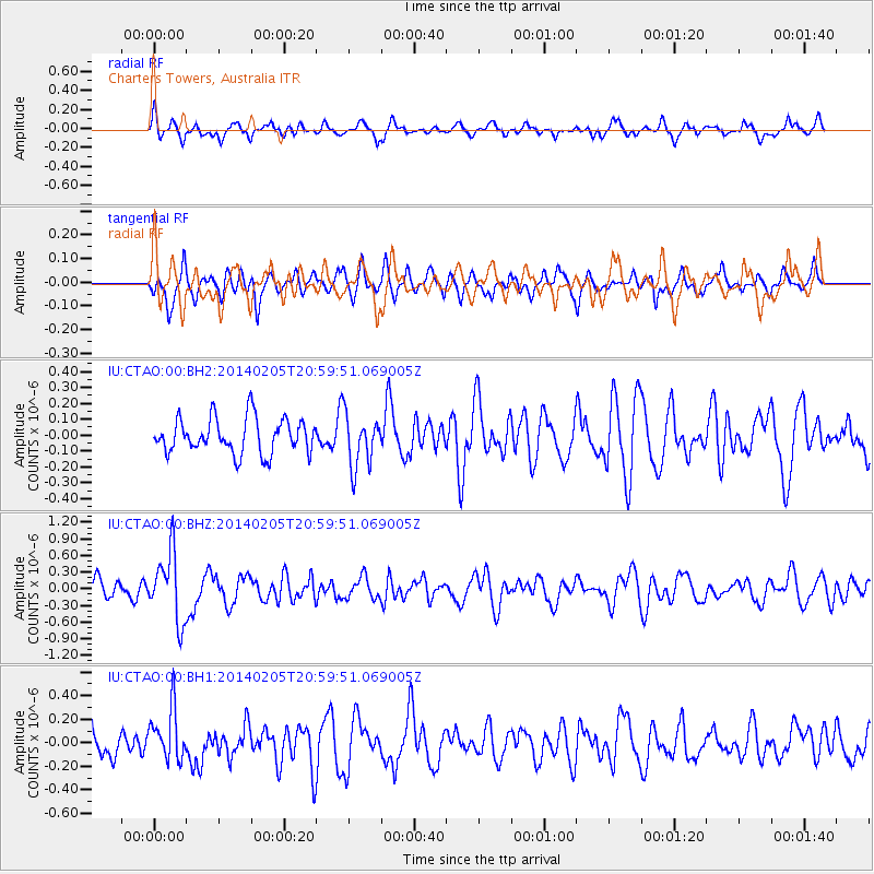
CTAO Charters Towers, Australia - Earthquake Result Viewer
*The percent match for this event was below the threshold and hence no stack was calculated.
| Earthquake location: |
Balleny Islands Region |
| Earthquake latitude/longitude: |
-61.4/154.5 |
| Earthquake time(UTC): |
2014/02/05 (036) 20:52:33 GMT |
| Earthquake Depth: |
10 km |
| Earthquake Magnitude: |
5.9 MWW, 5.8 MWB, 5.9 MWC |
| Earthquake Catalog/Contributor: |
NEIC PDE/NEIC COMCAT |
|
| Network: |
IU Global Seismograph Network (GSN - IRIS/USGS) |
| Station: |
CTAO Charters Towers, Australia |
| Lat/Lon: |
20.09 S/146.25 E |
| Elevation: |
357 m |
|
| Distance: |
41.7 deg |
| Az: |
348.367 deg |
| Baz: |
174.074 deg |
| Ray Param: |
$rayparam |
*The percent match for this event was below the threshold and hence was not used in the summary stack. |
|
| Radial Match: |
54.87949 % |
| Radial Bump: |
400 |
| Transverse Match: |
43.061283 % |
| Transverse Bump: |
348 |
| SOD ConfigId: |
626651 |
| Insert Time: |
2014-04-20 15:19:48.342 +0000 |
| GWidth: |
2.5 |
| Max Bumps: |
400 |
| Tol: |
0.001 |
|
Signal To Noise
| Channel | StoN | STA | LTA |
| IU:CTAO:00:BHZ:20140205T20:59:51.069005Z | 3.1444788 | 6.120911E-7 | 1.9465584E-7 |
| IU:CTAO:00:BH1:20140205T20:59:51.069005Z | 1.126195 | 2.1949847E-7 | 1.9490274E-7 |
| IU:CTAO:00:BH2:20140205T20:59:51.069005Z | 1.494769 | 1.6455117E-7 | 1.1008468E-7 |
| Arrivals |
| Ps | |
| PpPs | |
| PsPs/PpSs | |


