You are here: Home > Network List > IU - Global Seismograph Network (GSN - IRIS/USGS) Stations List
> Station PMG Port Moresby, New Guinea > Earthquake Result Viewer
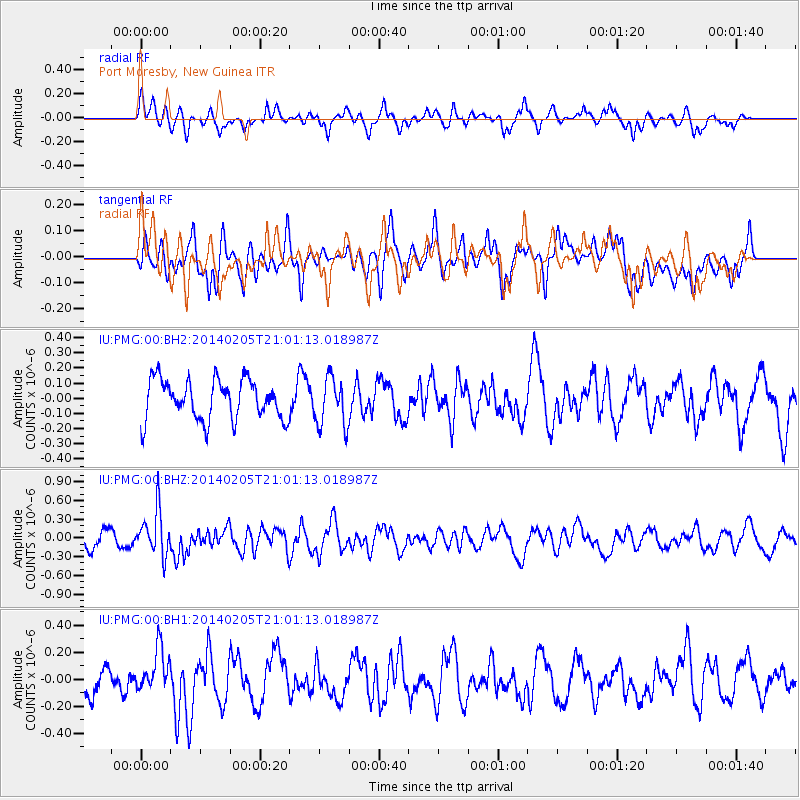
PMG Port Moresby, New Guinea - Earthquake Result Viewer
*The percent match for this event was below the threshold and hence no stack was calculated.
| Earthquake location: |
Balleny Islands Region |
| Earthquake latitude/longitude: |
-61.4/154.5 |
| Earthquake time(UTC): |
2014/02/05 (036) 20:52:33 GMT |
| Earthquake Depth: |
10 km |
| Earthquake Magnitude: |
5.9 MWW, 5.8 MWB, 5.9 MWC |
| Earthquake Catalog/Contributor: |
NEIC PDE/NEIC COMCAT |
|
| Network: |
IU Global Seismograph Network (GSN - IRIS/USGS) |
| Station: |
PMG Port Moresby, New Guinea |
| Lat/Lon: |
9.40 S/147.16 E |
| Elevation: |
90 m |
|
| Distance: |
52.2 deg |
| Az: |
350.873 deg |
| Baz: |
175.563 deg |
| Ray Param: |
$rayparam |
*The percent match for this event was below the threshold and hence was not used in the summary stack. |
|
| Radial Match: |
57.503613 % |
| Radial Bump: |
394 |
| Transverse Match: |
54.279278 % |
| Transverse Bump: |
400 |
| SOD ConfigId: |
626651 |
| Insert Time: |
2014-04-20 15:20:01.061 +0000 |
| GWidth: |
2.5 |
| Max Bumps: |
400 |
| Tol: |
0.001 |
|
Signal To Noise
| Channel | StoN | STA | LTA |
| IU:PMG:00:BHZ:20140205T21:01:13.018987Z | 2.7486734 | 3.5689774E-7 | 1.2984363E-7 |
| IU:PMG:00:BH1:20140205T21:01:13.018987Z | 1.166072 | 1.5244062E-7 | 1.3073002E-7 |
| IU:PMG:00:BH2:20140205T21:01:13.018987Z | 1.214239 | 1.593524E-7 | 1.3123643E-7 |
| Arrivals |
| Ps | |
| PpPs | |
| PsPs/PpSs | |


