You are here: Home > Network List > TA - USArray Transportable Network (new EarthScope stations) Stations List
> Station R11A Troy Canyon, Currant, NV, USA > Earthquake Result Viewer
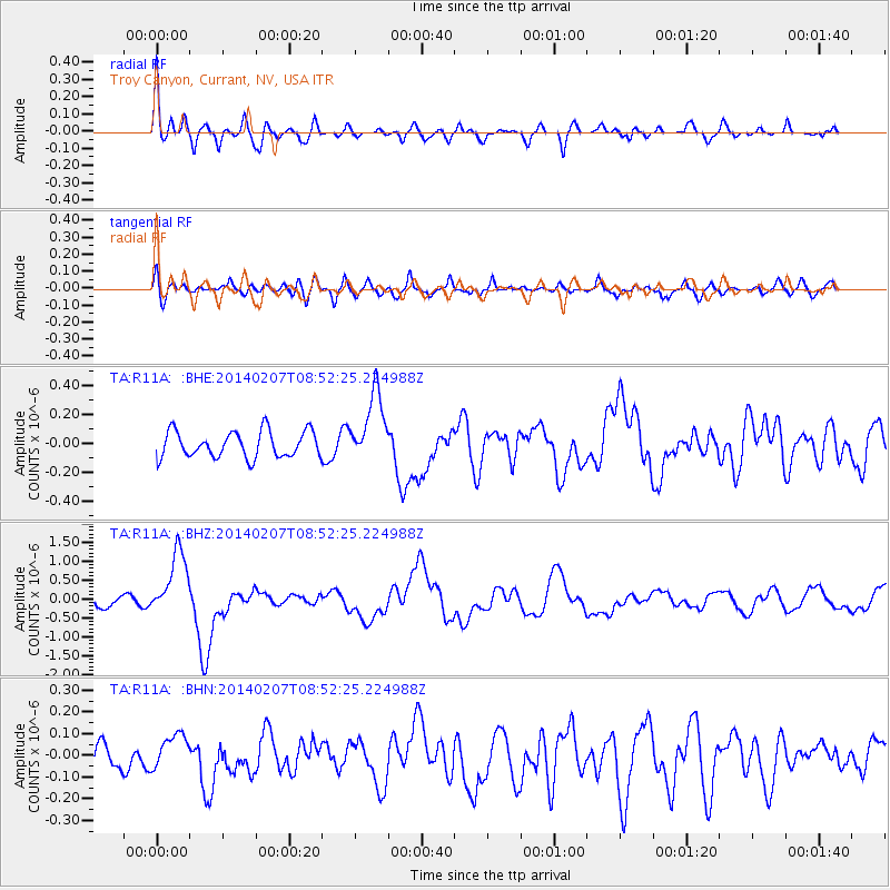
R11A Troy Canyon, Currant, NV, USA - Earthquake Result Viewer
*The percent match for this event was below the threshold and hence no stack was calculated.
| Earthquake location: |
Vanuatu Islands |
| Earthquake latitude/longitude: |
-15.1/167.4 |
| Earthquake time(UTC): |
2014/02/07 (038) 08:40:13 GMT |
| Earthquake Depth: |
122 km |
| Earthquake Magnitude: |
6.5 MWW, 6.5 MWC, 6.5 MWB, 6.5 MI |
| Earthquake Catalog/Contributor: |
NEIC PDE/NEIC COMCAT |
|
| Network: |
TA USArray Transportable Network (new EarthScope stations) |
| Station: |
R11A Troy Canyon, Currant, NV, USA |
| Lat/Lon: |
38.35 N/115.59 W |
| Elevation: |
1756 m |
|
| Distance: |
89.4 deg |
| Az: |
50.022 deg |
| Baz: |
250.306 deg |
| Ray Param: |
$rayparam |
*The percent match for this event was below the threshold and hence was not used in the summary stack. |
|
| Radial Match: |
76.546165 % |
| Radial Bump: |
400 |
| Transverse Match: |
64.785446 % |
| Transverse Bump: |
400 |
| SOD ConfigId: |
626651 |
| Insert Time: |
2014-04-20 16:04:26.585 +0000 |
| GWidth: |
2.5 |
| Max Bumps: |
400 |
| Tol: |
0.001 |
|
Signal To Noise
| Channel | StoN | STA | LTA |
| TA:R11A: :BHZ:20140207T08:52:25.224988Z | 8.003706 | 8.6682036E-7 | 1.0830237E-7 |
| TA:R11A: :BHN:20140207T08:52:25.224988Z | 0.7719114 | 6.6374604E-8 | 8.598733E-8 |
| TA:R11A: :BHE:20140207T08:52:25.224988Z | 2.6765103 | 2.4114587E-7 | 9.0097124E-8 |
| Arrivals |
| Ps | |
| PpPs | |
| PsPs/PpSs | |


