You are here: Home > Network List > G - GEOSCOPE Stations List
> Station MPG Montagne des Peres, French Guyana > Earthquake Result Viewer
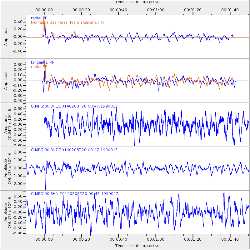
MPG Montagne des Peres, French Guyana - Earthquake Result Viewer
*The percent match for this event was below the threshold and hence no stack was calculated.
| Earthquake location: |
Scotia Sea |
| Earthquake latitude/longitude: |
-60.4/-45.2 |
| Earthquake time(UTC): |
2014/02/08 (039) 19:50:36 GMT |
| Earthquake Depth: |
24 km |
| Earthquake Magnitude: |
5.7 MWW, 5.6 MWB, 5.8 MWC |
| Earthquake Catalog/Contributor: |
NEIC PDE/NEIC COMCAT |
|
| Network: |
G GEOSCOPE |
| Station: |
MPG Montagne des Peres, French Guyana |
| Lat/Lon: |
5.11 N/52.64 W |
| Elevation: |
147 m |
|
| Distance: |
65.6 deg |
| Az: |
351.844 deg |
| Baz: |
175.948 deg |
| Ray Param: |
$rayparam |
*The percent match for this event was below the threshold and hence was not used in the summary stack. |
|
| Radial Match: |
69.50349 % |
| Radial Bump: |
400 |
| Transverse Match: |
50.225727 % |
| Transverse Bump: |
400 |
| SOD ConfigId: |
626651 |
| Insert Time: |
2014-04-20 16:11:05.082 +0000 |
| GWidth: |
2.5 |
| Max Bumps: |
400 |
| Tol: |
0.001 |
|
Signal To Noise
| Channel | StoN | STA | LTA |
| G:MPG:00:BHZ:20140208T20:00:47.199001Z | 2.6801176 | 7.481157E-7 | 2.791354E-7 |
| G:MPG:00:BHN:20140208T20:00:47.199001Z | 1.3753074 | 2.8851028E-7 | 2.0977873E-7 |
| G:MPG:00:BHE:20140208T20:00:47.199001Z | 0.73987335 | 1.8626427E-7 | 2.5175157E-7 |
| Arrivals |
| Ps | |
| PpPs | |
| PsPs/PpSs | |


