You are here: Home > Network List > II - Global Seismograph Network (GSN - IRIS/IDA) Stations List
> Station KIV Kislovodsk, Russia > Earthquake Result Viewer
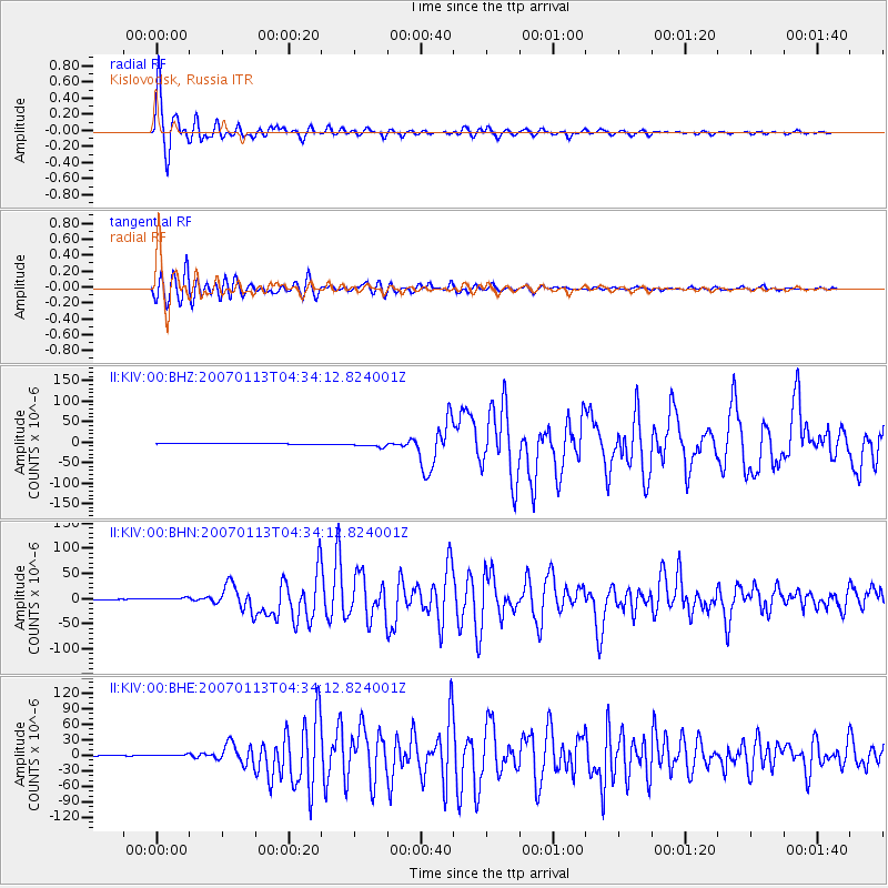
KIV Kislovodsk, Russia - Earthquake Result Viewer

| Earthquake location: |
East Of Kuril Islands |
| Earthquake latitude/longitude: |
46.2/154.5 |
| Earthquake time(UTC): |
2007/01/13 (013) 04:23:21 GMT |
| Earthquake Depth: |
10 km |
| Earthquake Magnitude: |
7.3 MB, 8.2 MS, 8.1 MW, 7.9 MW |
| Earthquake Catalog/Contributor: |
WHDF/NEIC |
|
| Network: |
II Global Seismograph Network (GSN - IRIS/IDA) |
| Station: |
KIV Kislovodsk, Russia |
| Lat/Lon: |
43.96 N/42.69 E |
| Elevation: |
1054 m |
|
| Distance: |
71.8 deg |
| Az: |
315.131 deg |
| Baz: |
42.684 deg |
| Ray Param: |
0.054053903 |
| Estimated Moho Depth: |
57.5 km |
| Estimated Crust Vp/Vs: |
1.63 |
| Assumed Crust Vp: |
6.247 km/s |
| Estimated Crust Vs: |
3.838 km/s |
| Estimated Crust Poisson's Ratio: |
0.20 |
|
| Radial Match: |
98.24431 % |
| Radial Bump: |
400 |
| Transverse Match: |
91.18172 % |
| Transverse Bump: |
400 |
| SOD ConfigId: |
2564 |
| Insert Time: |
2010-03-01 18:39:36.453 +0000 |
| GWidth: |
2.5 |
| Max Bumps: |
400 |
| Tol: |
0.001 |
|
Signal To Noise
| Channel | StoN | STA | LTA |
| II:KIV:00:BHN:20070113T04:34:12.824001Z | 9.14479 | 2.52261E-6 | 2.7585216E-7 |
| II:KIV:00:BHE:20070113T04:34:12.824001Z | 8.209877 | 1.9726976E-6 | 2.4028347E-7 |
| II:KIV:00:BHZ:20070113T04:34:12.824001Z | 16.178003 | 5.8414653E-6 | 3.6107454E-7 |
| Arrivals |
| Ps | 6.0 SECOND |
| PpPs | 23 SECOND |
| PsPs/PpSs | 29 SECOND |


