You are here: Home > Network List > AK - Alaska Regional Network Stations List
> Station GAMB Gambell Broadband > Earthquake Result Viewer
GAMB Gambell Broadband - Earthquake Result Viewer
| Earthquake location: |
Xizang |
| Earthquake latitude/longitude: |
35.9/82.6 |
| Earthquake time(UTC): |
2014/02/12 (043) 09:19:49 GMT |
| Earthquake Depth: |
10 km |
| Earthquake Magnitude: |
6.9 MWW, 6.9 MWB, 6.9 MWC |
| Earthquake Catalog/Contributor: |
NEIC PDE/NEIC COMCAT |
|
| Network: |
AK Alaska Regional Network |
| Station: |
GAMB Gambell Broadband |
| Lat/Lon: |
63.78 N/171.70 W |
| Elevation: |
10 m |
|
| Distance: |
64.8 deg |
| Az: |
28.2 deg |
| Baz: |
300.283 deg |
| Ray Param: |
0.058675025 |
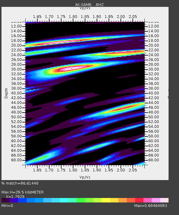
| Estimated Moho Depth: |
29.5 km |
| Estimated Crust Vp/Vs: |
1.79 |
| Assumed Crust Vp: |
6.24 km/s |
| Estimated Crust Vs: |
3.481 km/s |
| Estimated Crust Poisson's Ratio: |
0.27 |
|
| Radial Match: |
96.61448 % |
| Radial Bump: |
400 |
| Transverse Match: |
84.154236 % |
| Transverse Bump: |
400 |
| SOD ConfigId: |
626651 |
| Insert Time: |
2014-04-20 16:38:00.715 +0000 |
| GWidth: |
2.5 |
| Max Bumps: |
400 |
| Tol: |
0.001 |
|

Signal To Noise
| Channel | StoN | STA | LTA |
| AK:GAMB: :BHZ:20140212T09:29:56.807986Z | 6.2533593 | 1.1049087E-6 | 1.7669042E-7 |
| AK:GAMB: :BHN:20140212T09:29:56.807986Z | 2.5213354 | 4.743687E-7 | 1.8814184E-7 |
| AK:GAMB: :BHE:20140212T09:29:56.807986Z | 3.0067492 | 6.8409673E-7 | 2.2752039E-7 |
| Arrivals |
| Ps | 3.9 SECOND |
| PpPs | 13 SECOND |
| PsPs/PpSs | 17 SECOND |


