You are here: Home > Network List > AK - Alaska Regional Network Stations List
> Station NEA Nenana, AK, USA > Earthquake Result Viewer
NEA Nenana, AK, USA - Earthquake Result Viewer
| Earthquake location: |
Xizang |
| Earthquake latitude/longitude: |
35.9/82.6 |
| Earthquake time(UTC): |
2014/02/12 (043) 09:19:49 GMT |
| Earthquake Depth: |
10 km |
| Earthquake Magnitude: |
6.9 MWW, 6.9 MWB, 6.9 MWC |
| Earthquake Catalog/Contributor: |
NEIC PDE/NEIC COMCAT |
|
| Network: |
AK Alaska Regional Network |
| Station: |
NEA Nenana, AK, USA |
| Lat/Lon: |
64.59 N/149.07 W |
| Elevation: |
456 m |
|
| Distance: |
72.0 deg |
| Az: |
20.844 deg |
| Baz: |
317.963 deg |
| Ray Param: |
0.05397026 |
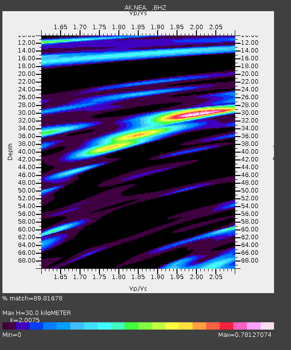
| Estimated Moho Depth: |
30.0 km |
| Estimated Crust Vp/Vs: |
2.01 |
| Assumed Crust Vp: |
6.566 km/s |
| Estimated Crust Vs: |
3.271 km/s |
| Estimated Crust Poisson's Ratio: |
0.33 |
|
| Radial Match: |
89.81678 % |
| Radial Bump: |
386 |
| Transverse Match: |
84.26603 % |
| Transverse Bump: |
356 |
| SOD ConfigId: |
626651 |
| Insert Time: |
2014-04-20 16:38:46.696 +0000 |
| GWidth: |
2.5 |
| Max Bumps: |
400 |
| Tol: |
0.001 |
|

Signal To Noise
| Channel | StoN | STA | LTA |
| AK:NEA: :BHZ:20140212T09:30:41.448Z | 18.117556 | 1.5520895E-6 | 8.5667715E-8 |
| AK:NEA: :BHN:20140212T09:30:41.448Z | 2.4974203 | 2.8247158E-7 | 1.1310534E-7 |
| AK:NEA: :BHE:20140212T09:30:41.448Z | 1.9324911 | 2.562181E-7 | 1.3258436E-7 |
| Arrivals |
| Ps | 4.8 SECOND |
| PpPs | 13 SECOND |
| PsPs/PpSs | 18 SECOND |


