You are here: Home > Network List > TA - USArray Transportable Network (new EarthScope stations) Stations List
> Station J01E Myrtle Point, OR, USA > Earthquake Result Viewer
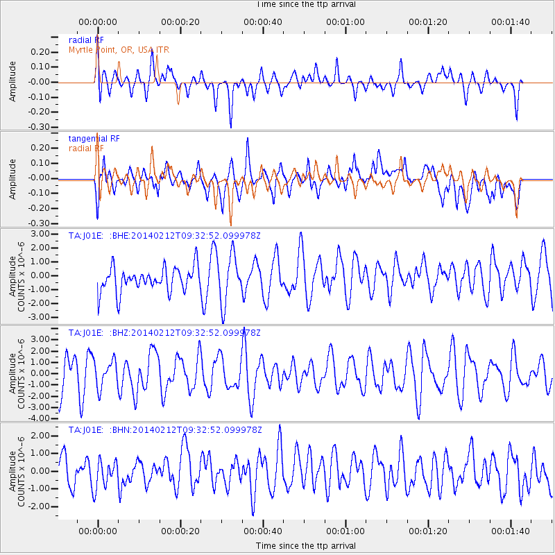
J01E Myrtle Point, OR, USA - Earthquake Result Viewer
*The percent match for this event was below the threshold and hence no stack was calculated.
| Earthquake location: |
Xizang |
| Earthquake latitude/longitude: |
35.9/82.6 |
| Earthquake time(UTC): |
2014/02/12 (043) 09:19:49 GMT |
| Earthquake Depth: |
10 km |
| Earthquake Magnitude: |
6.9 MWW, 6.9 MWB, 6.9 MWC |
| Earthquake Catalog/Contributor: |
NEIC PDE/NEIC COMCAT |
|
| Network: |
TA USArray Transportable Network (new EarthScope stations) |
| Station: |
J01E Myrtle Point, OR, USA |
| Lat/Lon: |
43.16 N/123.93 W |
| Elevation: |
128 m |
|
| Distance: |
97.7 deg |
| Az: |
19.247 deg |
| Baz: |
338.546 deg |
| Ray Param: |
$rayparam |
*The percent match for this event was below the threshold and hence was not used in the summary stack. |
|
| Radial Match: |
45.84442 % |
| Radial Bump: |
400 |
| Transverse Match: |
55.684944 % |
| Transverse Bump: |
400 |
| SOD ConfigId: |
626651 |
| Insert Time: |
2014-04-20 16:54:15.603 +0000 |
| GWidth: |
2.5 |
| Max Bumps: |
400 |
| Tol: |
0.001 |
|
Signal To Noise
| Channel | StoN | STA | LTA |
| TA:J01E: :BHZ:20140212T09:32:52.099978Z | 0.84295934 | 1.1764342E-6 | 1.3956003E-6 |
| TA:J01E: :BHN:20140212T09:32:52.099978Z | 0.6961775 | 7.7357504E-7 | 1.111175E-6 |
| TA:J01E: :BHE:20140212T09:32:52.099978Z | 1.9936953 | 1.7360964E-6 | 8.7079326E-7 |
| Arrivals |
| Ps | |
| PpPs | |
| PsPs/PpSs | |


