You are here: Home > Network List > TA - USArray Transportable Network (new EarthScope stations) Stations List
> Station G59A Clarenceville, QC, USA > Earthquake Result Viewer
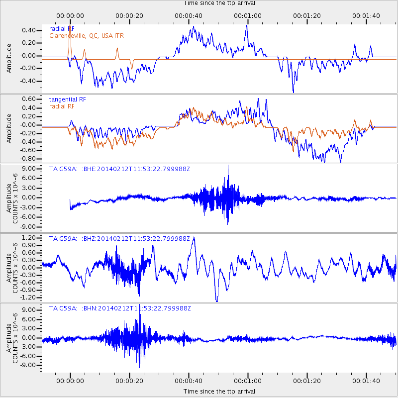
G59A Clarenceville, QC, USA - Earthquake Result Viewer
*The percent match for this event was below the threshold and hence no stack was calculated.
| Earthquake location: |
Northern Chile |
| Earthquake latitude/longitude: |
-22.4/-68.8 |
| Earthquake time(UTC): |
2014/02/12 (043) 11:43:10 GMT |
| Earthquake Depth: |
100 km |
| Earthquake Magnitude: |
5.6 MWW, 5.6 MWR |
| Earthquake Catalog/Contributor: |
NEIC PDE/NEIC COMCAT |
|
| Network: |
TA USArray Transportable Network (new EarthScope stations) |
| Station: |
G59A Clarenceville, QC, USA |
| Lat/Lon: |
45.08 N/73.18 W |
| Elevation: |
36 m |
|
| Distance: |
67.2 deg |
| Az: |
356.645 deg |
| Baz: |
175.614 deg |
| Ray Param: |
$rayparam |
*The percent match for this event was below the threshold and hence was not used in the summary stack. |
|
| Radial Match: |
52.069923 % |
| Radial Bump: |
400 |
| Transverse Match: |
49.9671 % |
| Transverse Bump: |
400 |
| SOD ConfigId: |
626651 |
| Insert Time: |
2014-04-20 17:23:44.826 +0000 |
| GWidth: |
2.5 |
| Max Bumps: |
400 |
| Tol: |
0.001 |
|
Signal To Noise
| Channel | StoN | STA | LTA |
| TA:G59A: :BHZ:20140212T11:53:22.799988Z | 1.414118 | 3.9302756E-7 | 2.779312E-7 |
| TA:G59A: :BHN:20140212T11:53:22.799988Z | 1.0221413 | 4.688875E-7 | 4.5873063E-7 |
| TA:G59A: :BHE:20140212T11:53:22.799988Z | 0.57438505 | 5.822136E-7 | 1.0136295E-6 |
| Arrivals |
| Ps | |
| PpPs | |
| PsPs/PpSs | |


