You are here: Home > Network List > TA - USArray Transportable Network (new EarthScope stations) Stations List
> Station P56A Dayton Farm, Ripley, WV, USA > Earthquake Result Viewer
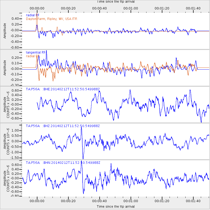
P56A Dayton Farm, Ripley, WV, USA - Earthquake Result Viewer
*The percent match for this event was below the threshold and hence no stack was calculated.
| Earthquake location: |
Northern Chile |
| Earthquake latitude/longitude: |
-22.4/-68.8 |
| Earthquake time(UTC): |
2014/02/12 (043) 11:43:10 GMT |
| Earthquake Depth: |
100 km |
| Earthquake Magnitude: |
5.6 MWW, 5.6 MWR |
| Earthquake Catalog/Contributor: |
NEIC PDE/NEIC COMCAT |
|
| Network: |
TA USArray Transportable Network (new EarthScope stations) |
| Station: |
P56A Dayton Farm, Ripley, WV, USA |
| Lat/Lon: |
39.50 N/78.84 W |
| Elevation: |
249 m |
|
| Distance: |
62.2 deg |
| Az: |
351.246 deg |
| Baz: |
169.507 deg |
| Ray Param: |
$rayparam |
*The percent match for this event was below the threshold and hence was not used in the summary stack. |
|
| Radial Match: |
51.083145 % |
| Radial Bump: |
400 |
| Transverse Match: |
59.716785 % |
| Transverse Bump: |
400 |
| SOD ConfigId: |
626651 |
| Insert Time: |
2014-04-20 17:27:08.561 +0000 |
| GWidth: |
2.5 |
| Max Bumps: |
400 |
| Tol: |
0.001 |
|
Signal To Noise
| Channel | StoN | STA | LTA |
| TA:P56A: :BHZ:20140212T11:52:50.549988Z | 1.1441051 | 2.6351802E-7 | 2.3032675E-7 |
| TA:P56A: :BHN:20140212T11:52:50.549988Z | 1.2437721 | 1.9840752E-7 | 1.5952078E-7 |
| TA:P56A: :BHE:20140212T11:52:50.549988Z | 2.3710573 | 4.5769764E-7 | 1.9303526E-7 |
| Arrivals |
| Ps | |
| PpPs | |
| PsPs/PpSs | |


