You are here: Home > Network List > TA - USArray Transportable Network (new EarthScope stations) Stations List
> Station Q48A North Vernon, IN, USA > Earthquake Result Viewer
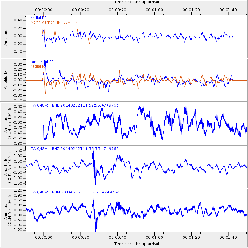
Q48A North Vernon, IN, USA - Earthquake Result Viewer
*The percent match for this event was below the threshold and hence no stack was calculated.
| Earthquake location: |
Northern Chile |
| Earthquake latitude/longitude: |
-22.4/-68.8 |
| Earthquake time(UTC): |
2014/02/12 (043) 11:43:10 GMT |
| Earthquake Depth: |
100 km |
| Earthquake Magnitude: |
5.6 MWW, 5.6 MWR |
| Earthquake Catalog/Contributor: |
NEIC PDE/NEIC COMCAT |
|
| Network: |
TA USArray Transportable Network (new EarthScope stations) |
| Station: |
Q48A North Vernon, IN, USA |
| Lat/Lon: |
38.93 N/85.73 W |
| Elevation: |
185 m |
|
| Distance: |
63.0 deg |
| Az: |
345.24 deg |
| Baz: |
162.399 deg |
| Ray Param: |
$rayparam |
*The percent match for this event was below the threshold and hence was not used in the summary stack. |
|
| Radial Match: |
50.985603 % |
| Radial Bump: |
370 |
| Transverse Match: |
53.751026 % |
| Transverse Bump: |
400 |
| SOD ConfigId: |
626651 |
| Insert Time: |
2014-04-20 17:27:20.392 +0000 |
| GWidth: |
2.5 |
| Max Bumps: |
400 |
| Tol: |
0.001 |
|
Signal To Noise
| Channel | StoN | STA | LTA |
| TA:Q48A: :BHZ:20140212T11:52:55.474976Z | 1.201151 | 2.9045788E-7 | 2.4181628E-7 |
| TA:Q48A: :BHN:20140212T11:52:55.474976Z | 1.346869 | 3.8416968E-7 | 2.8523164E-7 |
| TA:Q48A: :BHE:20140212T11:52:55.474976Z | 1.5762042 | 4.2694535E-7 | 2.7086932E-7 |
| Arrivals |
| Ps | |
| PpPs | |
| PsPs/PpSs | |


