You are here: Home > Network List > II - Global Seismograph Network (GSN - IRIS/IDA) Stations List
> Station WRAB Tennant Creek, NT, Australia > Earthquake Result Viewer
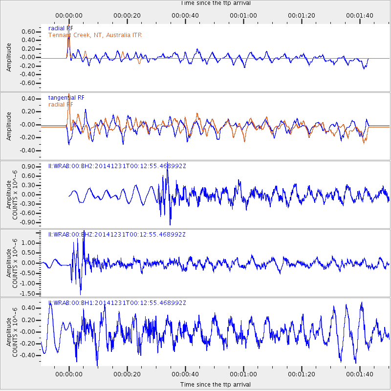
WRAB Tennant Creek, NT, Australia - Earthquake Result Viewer
*The percent match for this event was below the threshold and hence no stack was calculated.
| Earthquake location: |
Fiji Islands Region |
| Earthquake latitude/longitude: |
-20.3/-178.5 |
| Earthquake time(UTC): |
2014/12/31 (365) 00:06:09 GMT |
| Earthquake Depth: |
606 km |
| Earthquake Magnitude: |
5.9 MW, 5.4 mb |
| Earthquake Catalog/Contributor: |
ISC/ISC |
|
| Network: |
II Global Seismograph Network (GSN - IRIS/IDA) |
| Station: |
WRAB Tennant Creek, NT, Australia |
| Lat/Lon: |
19.93 S/134.36 E |
| Elevation: |
366 m |
|
| Distance: |
44.1 deg |
| Az: |
261.98 deg |
| Baz: |
98.933 deg |
| Ray Param: |
$rayparam |
*The percent match for this event was below the threshold and hence was not used in the summary stack. |
|
| Radial Match: |
53.65265 % |
| Radial Bump: |
400 |
| Transverse Match: |
54.464798 % |
| Transverse Bump: |
365 |
| SOD ConfigId: |
3390531 |
| Insert Time: |
2019-04-15 21:15:33.017 +0000 |
| GWidth: |
2.5 |
| Max Bumps: |
400 |
| Tol: |
0.001 |
|
Signal To Noise
| Channel | StoN | STA | LTA |
| II:WRAB:00:BHZ:20141231T00:12:55.468992Z | 7.0248246 | 6.059561E-7 | 8.625925E-8 |
| II:WRAB:00:BH1:20141231T00:12:55.468992Z | 0.7833957 | 1.604338E-7 | 2.047928E-7 |
| II:WRAB:00:BH2:20141231T00:12:55.468992Z | 2.6962209 | 3.7401503E-7 | 1.3871825E-7 |
| Arrivals |
| Ps | |
| PpPs | |
| PsPs/PpSs | |


