You are here: Home > Network List > UW - Pacific Northwest Regional Seismic Network Stations List
> Station PASS Maple Falls, WA, USA > Earthquake Result Viewer
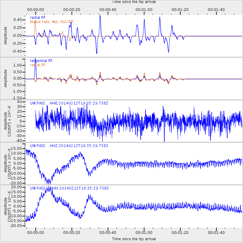
PASS Maple Falls, WA, USA - Earthquake Result Viewer
*The percent match for this event was below the threshold and hence no stack was calculated.
| Earthquake location: |
Vanuatu Islands |
| Earthquake latitude/longitude: |
-20.6/169.9 |
| Earthquake time(UTC): |
2014/02/12 (043) 19:22:53 GMT |
| Earthquake Depth: |
12 km |
| Earthquake Magnitude: |
5.6 MWW, 5.7 MWC |
| Earthquake Catalog/Contributor: |
NEIC PDE/NEIC COMCAT |
|
| Network: |
UW Pacific Northwest Regional Seismic Network |
| Station: |
PASS Maple Falls, WA, USA |
| Lat/Lon: |
49.00 N/122.09 W |
| Elevation: |
174 m |
|
| Distance: |
91.9 deg |
| Az: |
37.679 deg |
| Baz: |
240.38 deg |
| Ray Param: |
$rayparam |
*The percent match for this event was below the threshold and hence was not used in the summary stack. |
|
| Radial Match: |
33.1322 % |
| Radial Bump: |
400 |
| Transverse Match: |
89.99257 % |
| Transverse Bump: |
312 |
| SOD ConfigId: |
626651 |
| Insert Time: |
2014-04-20 17:45:39.860 +0000 |
| GWidth: |
2.5 |
| Max Bumps: |
400 |
| Tol: |
0.001 |
|
Signal To Noise
| Channel | StoN | STA | LTA |
| UW:PASS: :HHZ:20140212T19:35:29.738Z | 2.7805114 | 1.1980188E-5 | 4.308628E-6 |
| UW:PASS: :HHN:20140212T19:35:29.738Z | 2.7871463 | 1.2495532E-5 | 4.483271E-6 |
| UW:PASS: :HHE:20140212T19:35:29.738Z | 1.1820327 | 1.370966E-5 | 1.1598377E-5 |
| Arrivals |
| Ps | |
| PpPs | |
| PsPs/PpSs | |


