You are here: Home > Network List > TA - USArray Transportable Network (new EarthScope stations) Stations List
> Station 121A Cookes Peak, Deming, NM, USA > Earthquake Result Viewer
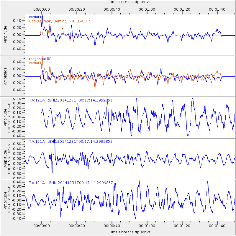
121A Cookes Peak, Deming, NM, USA - Earthquake Result Viewer
*The percent match for this event was below the threshold and hence no stack was calculated.
| Earthquake location: |
Fiji Islands Region |
| Earthquake latitude/longitude: |
-20.3/-178.5 |
| Earthquake time(UTC): |
2014/12/31 (365) 00:06:09 GMT |
| Earthquake Depth: |
606 km |
| Earthquake Magnitude: |
5.9 MW, 5.4 mb |
| Earthquake Catalog/Contributor: |
ISC/ISC |
|
| Network: |
TA USArray Transportable Network (new EarthScope stations) |
| Station: |
121A Cookes Peak, Deming, NM, USA |
| Lat/Lon: |
32.53 N/107.79 W |
| Elevation: |
1652 m |
|
| Distance: |
85.6 deg |
| Az: |
53.12 deg |
| Baz: |
242.72 deg |
| Ray Param: |
$rayparam |
*The percent match for this event was below the threshold and hence was not used in the summary stack. |
|
| Radial Match: |
52.256973 % |
| Radial Bump: |
400 |
| Transverse Match: |
50.69447 % |
| Transverse Bump: |
400 |
| SOD ConfigId: |
3390531 |
| Insert Time: |
2019-04-15 21:16:51.601 +0000 |
| GWidth: |
2.5 |
| Max Bumps: |
400 |
| Tol: |
0.001 |
|
Signal To Noise
| Channel | StoN | STA | LTA |
| TA:121A: :BHZ:20141231T00:17:14.299985Z | 3.2806437 | 2.1109437E-7 | 6.4345414E-8 |
| TA:121A: :BHN:20141231T00:17:14.299985Z | 0.8531694 | 7.3031494E-8 | 8.560023E-8 |
| TA:121A: :BHE:20141231T00:17:14.299985Z | 0.9510047 | 1.3066905E-7 | 1.3740106E-7 |
| Arrivals |
| Ps | |
| PpPs | |
| PsPs/PpSs | |


