You are here: Home > Network List > TA - USArray Transportable Network (new EarthScope stations) Stations List
> Station A04D Lummi Island, WA, USA > Earthquake Result Viewer
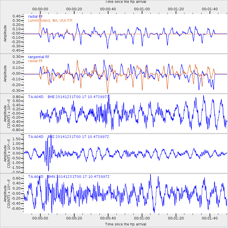
A04D Lummi Island, WA, USA - Earthquake Result Viewer
*The percent match for this event was below the threshold and hence no stack was calculated.
| Earthquake location: |
Fiji Islands Region |
| Earthquake latitude/longitude: |
-20.3/-178.5 |
| Earthquake time(UTC): |
2014/12/31 (365) 00:06:09 GMT |
| Earthquake Depth: |
606 km |
| Earthquake Magnitude: |
5.9 MW, 5.4 mb |
| Earthquake Catalog/Contributor: |
ISC/ISC |
|
| Network: |
TA USArray Transportable Network (new EarthScope stations) |
| Station: |
A04D Lummi Island, WA, USA |
| Lat/Lon: |
48.72 N/122.71 W |
| Elevation: |
13 m |
|
| Distance: |
84.8 deg |
| Az: |
33.383 deg |
| Baz: |
231.247 deg |
| Ray Param: |
$rayparam |
*The percent match for this event was below the threshold and hence was not used in the summary stack. |
|
| Radial Match: |
67.19522 % |
| Radial Bump: |
400 |
| Transverse Match: |
73.24247 % |
| Transverse Bump: |
400 |
| SOD ConfigId: |
3390531 |
| Insert Time: |
2019-04-15 21:16:51.853 +0000 |
| GWidth: |
2.5 |
| Max Bumps: |
400 |
| Tol: |
0.001 |
|
Signal To Noise
| Channel | StoN | STA | LTA |
| TA:A04D: :BHZ:20141231T00:17:10.473997Z | 3.1802502 | 6.548836E-7 | 2.0592203E-7 |
| TA:A04D: :BHN:20141231T00:17:10.473997Z | 1.8058293 | 4.2390064E-7 | 2.3474017E-7 |
| TA:A04D: :BHE:20141231T00:17:10.473997Z | 0.90890324 | 1.9663386E-7 | 2.163419E-7 |
| Arrivals |
| Ps | |
| PpPs | |
| PsPs/PpSs | |


