You are here: Home > Network List > II - Global Seismograph Network (GSN - IRIS/IDA) Stations List
> Station PFO Pinon Flat, California, USA > Earthquake Result Viewer
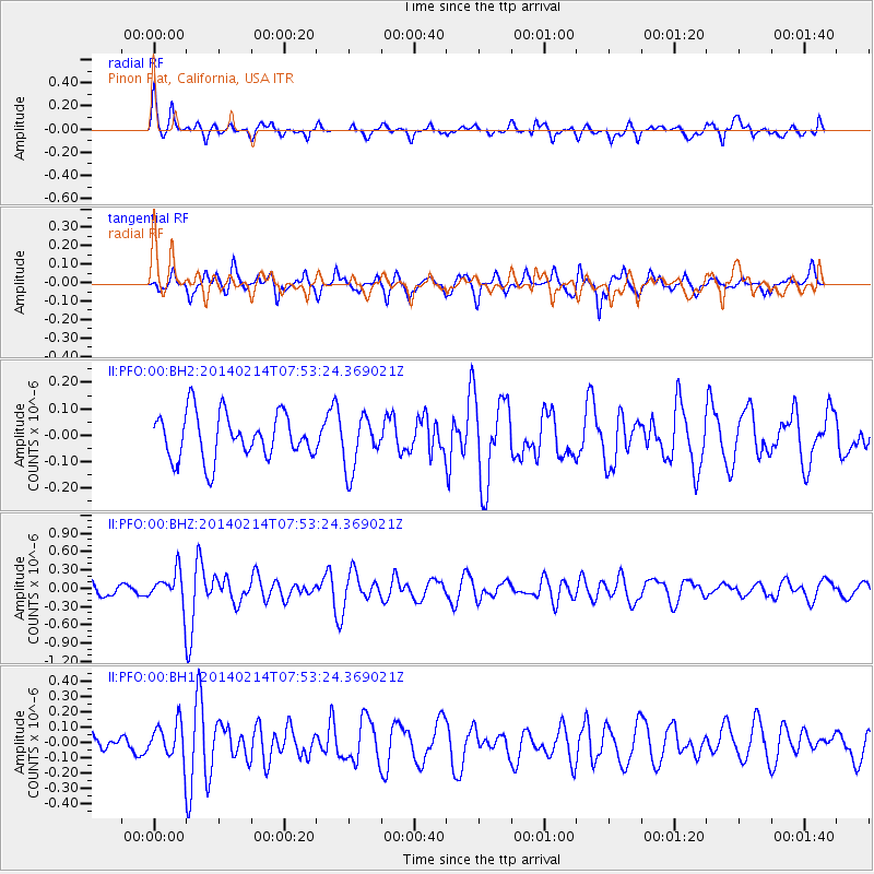
PFO Pinon Flat, California, USA - Earthquake Result Viewer
*The percent match for this event was below the threshold and hence no stack was calculated.
| Earthquake location: |
Easter Island Region |
| Earthquake latitude/longitude: |
-23.0/-114.3 |
| Earthquake time(UTC): |
2014/02/14 (045) 07:44:15 GMT |
| Earthquake Depth: |
12 km |
| Earthquake Magnitude: |
5.6 MWW, 5.5 MWB, 5.6 MWC |
| Earthquake Catalog/Contributor: |
NEIC PDE/NEIC COMCAT |
|
| Network: |
II Global Seismograph Network (GSN - IRIS/IDA) |
| Station: |
PFO Pinon Flat, California, USA |
| Lat/Lon: |
33.61 N/116.46 W |
| Elevation: |
1280 m |
|
| Distance: |
56.3 deg |
| Az: |
357.868 deg |
| Baz: |
177.645 deg |
| Ray Param: |
$rayparam |
*The percent match for this event was below the threshold and hence was not used in the summary stack. |
|
| Radial Match: |
60.63164 % |
| Radial Bump: |
400 |
| Transverse Match: |
54.23691 % |
| Transverse Bump: |
400 |
| SOD ConfigId: |
626651 |
| Insert Time: |
2014-04-20 17:55:20.207 +0000 |
| GWidth: |
2.5 |
| Max Bumps: |
400 |
| Tol: |
0.001 |
|
Signal To Noise
| Channel | StoN | STA | LTA |
| II:PFO:00:BHZ:20140214T07:53:24.369021Z | 1.6986272 | 2.8774318E-7 | 1.6939748E-7 |
| II:PFO:00:BH1:20140214T07:53:24.369021Z | 1.3888518 | 1.2347E-7 | 8.890077E-8 |
| II:PFO:00:BH2:20140214T07:53:24.369021Z | 1.1918768 | 1.0163491E-7 | 8.5273E-8 |
| Arrivals |
| Ps | |
| PpPs | |
| PsPs/PpSs | |


