You are here: Home > Network List > UW - Pacific Northwest Regional Seismic Network Stations List
> Station UMAT Pilot Rock, OR, USA > Earthquake Result Viewer
UMAT Pilot Rock, OR, USA - Earthquake Result Viewer
*The percent match for this event was below the threshold and hence no stack was calculated.
| Earthquake location: |
Fiji Islands Region |
| Earthquake latitude/longitude: |
-20.3/-178.5 |
| Earthquake time(UTC): |
2014/12/31 (365) 00:06:09 GMT |
| Earthquake Depth: |
606 km |
| Earthquake Magnitude: |
5.9 MW, 5.4 mb |
| Earthquake Catalog/Contributor: |
ISC/ISC |
|
| Network: |
UW Pacific Northwest Regional Seismic Network |
| Station: |
UMAT Pilot Rock, OR, USA |
| Lat/Lon: |
45.29 N/118.96 W |
| Elevation: |
1318 m |
|
| Distance: |
84.8 deg |
| Az: |
37.683 deg |
| Baz: |
234.371 deg |
| Ray Param: |
$rayparam |
*The percent match for this event was below the threshold and hence was not used in the summary stack. |
|
| Radial Match: |
68.87455 % |
| Radial Bump: |
379 |
| Transverse Match: |
65.97247 % |
| Transverse Bump: |
342 |
| SOD ConfigId: |
3390531 |
| Insert Time: |
2019-04-15 21:17:55.221 +0000 |
| GWidth: |
2.5 |
| Max Bumps: |
400 |
| Tol: |
0.001 |
|
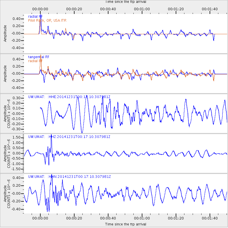
Signal To Noise
| Channel | StoN | STA | LTA |
| UW:UMAT: :HHZ:20141231T00:17:10.307981Z | 1.8858514 | 3.292685E-7 | 1.7459939E-7 |
| UW:UMAT: :HHN:20141231T00:17:10.307981Z | 2.2713397 | 2.4419975E-7 | 1.0751353E-7 |
| UW:UMAT: :HHE:20141231T00:17:10.307981Z | 0.86244786 | 1.3392172E-7 | 1.5528094E-7 |
| Arrivals |
| Ps | |
| PpPs | |
| PsPs/PpSs | |


