You are here: Home > Network List > TA - USArray Transportable Network (new EarthScope stations) Stations List
> Station L48A N Adams, MI, USA > Earthquake Result Viewer
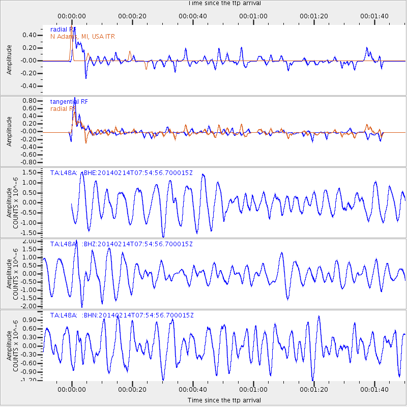
L48A N Adams, MI, USA - Earthquake Result Viewer
*The percent match for this event was below the threshold and hence no stack was calculated.
| Earthquake location: |
Easter Island Region |
| Earthquake latitude/longitude: |
-23.0/-114.3 |
| Earthquake time(UTC): |
2014/02/14 (045) 07:44:15 GMT |
| Earthquake Depth: |
12 km |
| Earthquake Magnitude: |
5.6 MWW, 5.5 MWB, 5.6 MWC |
| Earthquake Catalog/Contributor: |
NEIC PDE/NEIC COMCAT |
|
| Network: |
TA USArray Transportable Network (new EarthScope stations) |
| Station: |
L48A N Adams, MI, USA |
| Lat/Lon: |
41.94 N/84.43 W |
| Elevation: |
369 m |
|
| Distance: |
70.3 deg |
| Az: |
23.272 deg |
| Baz: |
209.219 deg |
| Ray Param: |
$rayparam |
*The percent match for this event was below the threshold and hence was not used in the summary stack. |
|
| Radial Match: |
63.953274 % |
| Radial Bump: |
400 |
| Transverse Match: |
83.47563 % |
| Transverse Bump: |
400 |
| SOD ConfigId: |
626651 |
| Insert Time: |
2014-04-20 18:07:03.267 +0000 |
| GWidth: |
2.5 |
| Max Bumps: |
400 |
| Tol: |
0.001 |
|
Signal To Noise
| Channel | StoN | STA | LTA |
| TA:L48A: :BHZ:20140214T07:54:56.700015Z | 2.067929 | 1.1852424E-6 | 5.7315424E-7 |
| TA:L48A: :BHN:20140214T07:54:56.700015Z | 1.0799955 | 4.5515188E-7 | 4.2143864E-7 |
| TA:L48A: :BHE:20140214T07:54:56.700015Z | 1.2138745 | 8.6883205E-7 | 7.157512E-7 |
| Arrivals |
| Ps | |
| PpPs | |
| PsPs/PpSs | |


