You are here: Home > Network List > TA - USArray Transportable Network (new EarthScope stations) Stations List
> Station P59A Jarrettsville, MD, USA > Earthquake Result Viewer
P59A Jarrettsville, MD, USA - Earthquake Result Viewer
*The percent match for this event was below the threshold and hence no stack was calculated.
| Earthquake location: |
Easter Island Region |
| Earthquake latitude/longitude: |
-23.0/-114.3 |
| Earthquake time(UTC): |
2014/02/14 (045) 07:44:15 GMT |
| Earthquake Depth: |
12 km |
| Earthquake Magnitude: |
5.6 MWW, 5.5 MWB, 5.6 MWC |
| Earthquake Catalog/Contributor: |
NEIC PDE/NEIC COMCAT |
|
| Network: |
TA USArray Transportable Network (new EarthScope stations) |
| Station: |
P59A Jarrettsville, MD, USA |
| Lat/Lon: |
39.61 N/76.43 W |
| Elevation: |
157 m |
|
| Distance: |
71.6 deg |
| Az: |
30.005 deg |
| Baz: |
216.633 deg |
| Ray Param: |
$rayparam |
*The percent match for this event was below the threshold and hence was not used in the summary stack. |
|
| Radial Match: |
38.27426 % |
| Radial Bump: |
400 |
| Transverse Match: |
42.210415 % |
| Transverse Bump: |
400 |
| SOD ConfigId: |
626651 |
| Insert Time: |
2014-04-20 18:08:44.674 +0000 |
| GWidth: |
2.5 |
| Max Bumps: |
400 |
| Tol: |
0.001 |
|
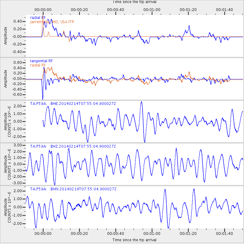
Signal To Noise
| Channel | StoN | STA | LTA |
| TA:P59A: :BHZ:20140214T07:55:04.900027Z | 1.3754508 | 1.7323302E-6 | 1.2594636E-6 |
| TA:P59A: :BHN:20140214T07:55:04.900027Z | 1.1619191 | 1.2352817E-6 | 1.0631392E-6 |
| TA:P59A: :BHE:20140214T07:55:04.900027Z | 0.5936297 | 6.081852E-7 | 1.0245194E-6 |
| Arrivals |
| Ps | |
| PpPs | |
| PsPs/PpSs | |


