You are here: Home > Network List > TA - USArray Transportable Network (new EarthScope stations) Stations List
> Station S52A Salyersville, KY, USA > Earthquake Result Viewer
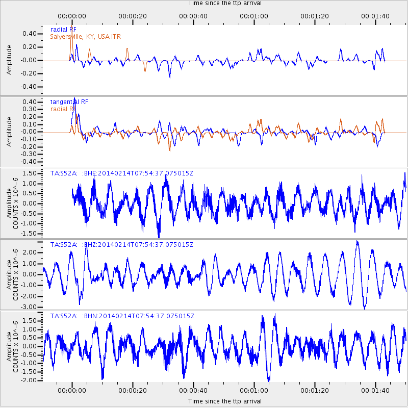
S52A Salyersville, KY, USA - Earthquake Result Viewer
*The percent match for this event was below the threshold and hence no stack was calculated.
| Earthquake location: |
Easter Island Region |
| Earthquake latitude/longitude: |
-23.0/-114.3 |
| Earthquake time(UTC): |
2014/02/14 (045) 07:44:15 GMT |
| Earthquake Depth: |
12 km |
| Earthquake Magnitude: |
5.6 MWW, 5.5 MWB, 5.6 MWC |
| Earthquake Catalog/Contributor: |
NEIC PDE/NEIC COMCAT |
|
| Network: |
TA USArray Transportable Network (new EarthScope stations) |
| Station: |
S52A Salyersville, KY, USA |
| Lat/Lon: |
37.68 N/83.08 W |
| Elevation: |
367 m |
|
| Distance: |
67.1 deg |
| Az: |
26.542 deg |
| Baz: |
211.274 deg |
| Ray Param: |
$rayparam |
*The percent match for this event was below the threshold and hence was not used in the summary stack. |
|
| Radial Match: |
52.41663 % |
| Radial Bump: |
400 |
| Transverse Match: |
66.45761 % |
| Transverse Bump: |
400 |
| SOD ConfigId: |
626651 |
| Insert Time: |
2014-04-20 18:09:30.954 +0000 |
| GWidth: |
2.5 |
| Max Bumps: |
400 |
| Tol: |
0.001 |
|
Signal To Noise
| Channel | StoN | STA | LTA |
| TA:S52A: :BHZ:20140214T07:54:37.075015Z | 1.8646146 | 1.6251507E-6 | 8.715746E-7 |
| TA:S52A: :BHN:20140214T07:54:37.075015Z | 0.5580309 | 4.5646732E-7 | 8.179965E-7 |
| TA:S52A: :BHE:20140214T07:54:37.075015Z | 1.4026662 | 7.1711435E-7 | 5.1125085E-7 |
| Arrivals |
| Ps | |
| PpPs | |
| PsPs/PpSs | |


