You are here: Home > Network List > TA - USArray Transportable Network (new EarthScope stations) Stations List
> Station U57A Blanch, NC, USA > Earthquake Result Viewer
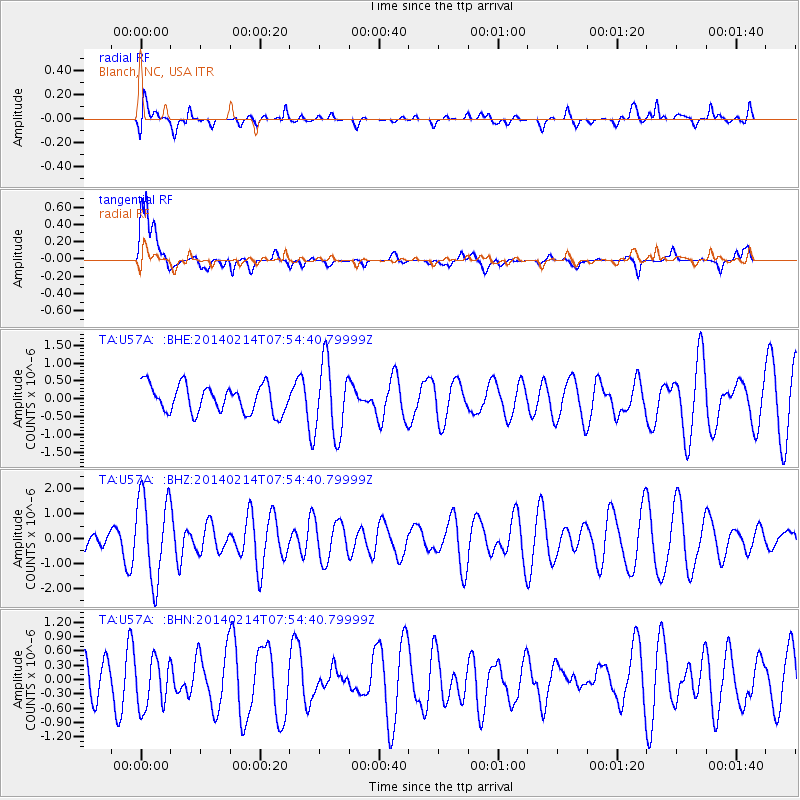
U57A Blanch, NC, USA - Earthquake Result Viewer
*The percent match for this event was below the threshold and hence no stack was calculated.
| Earthquake location: |
Easter Island Region |
| Earthquake latitude/longitude: |
-23.0/-114.3 |
| Earthquake time(UTC): |
2014/02/14 (045) 07:44:15 GMT |
| Earthquake Depth: |
12 km |
| Earthquake Magnitude: |
5.6 MWW, 5.5 MWB, 5.6 MWC |
| Earthquake Catalog/Contributor: |
NEIC PDE/NEIC COMCAT |
|
| Network: |
TA USArray Transportable Network (new EarthScope stations) |
| Station: |
U57A Blanch, NC, USA |
| Lat/Lon: |
36.43 N/79.34 W |
| Elevation: |
178 m |
|
| Distance: |
67.7 deg |
| Az: |
29.995 deg |
| Baz: |
214.848 deg |
| Ray Param: |
$rayparam |
*The percent match for this event was below the threshold and hence was not used in the summary stack. |
|
| Radial Match: |
43.34169 % |
| Radial Bump: |
400 |
| Transverse Match: |
72.59887 % |
| Transverse Bump: |
389 |
| SOD ConfigId: |
626651 |
| Insert Time: |
2014-04-20 18:10:15.310 +0000 |
| GWidth: |
2.5 |
| Max Bumps: |
400 |
| Tol: |
0.001 |
|
Signal To Noise
| Channel | StoN | STA | LTA |
| TA:U57A: :BHZ:20140214T07:54:40.79999Z | 3.2803228 | 1.7085927E-6 | 5.2086114E-7 |
| TA:U57A: :BHN:20140214T07:54:40.79999Z | 1.046433 | 5.287251E-7 | 5.0526415E-7 |
| TA:U57A: :BHE:20140214T07:54:40.79999Z | 2.6636393 | 1.0278136E-6 | 3.8586813E-7 |
| Arrivals |
| Ps | |
| PpPs | |
| PsPs/PpSs | |


