You are here: Home > Network List > US - United States National Seismic Network Stations List
> Station WMOK Wichita Mountains, Oklahoma, USA > Earthquake Result Viewer
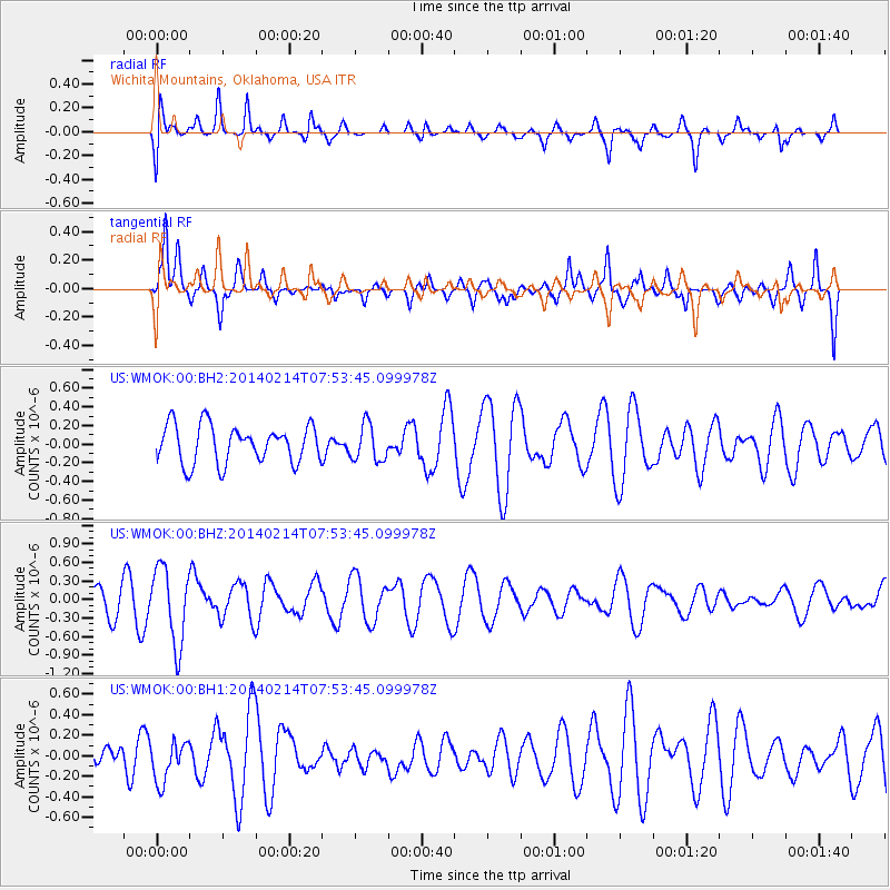
WMOK Wichita Mountains, Oklahoma, USA - Earthquake Result Viewer
*The percent match for this event was below the threshold and hence no stack was calculated.
| Earthquake location: |
Easter Island Region |
| Earthquake latitude/longitude: |
-23.0/-114.3 |
| Earthquake time(UTC): |
2014/02/14 (045) 07:44:15 GMT |
| Earthquake Depth: |
12 km |
| Earthquake Magnitude: |
5.6 MWW, 5.5 MWB, 5.6 MWC |
| Earthquake Catalog/Contributor: |
NEIC PDE/NEIC COMCAT |
|
| Network: |
US United States National Seismic Network |
| Station: |
WMOK Wichita Mountains, Oklahoma, USA |
| Lat/Lon: |
34.74 N/98.78 W |
| Elevation: |
486 m |
|
| Distance: |
59.2 deg |
| Az: |
14.886 deg |
| Baz: |
196.71 deg |
| Ray Param: |
$rayparam |
*The percent match for this event was below the threshold and hence was not used in the summary stack. |
|
| Radial Match: |
69.0598 % |
| Radial Bump: |
400 |
| Transverse Match: |
63.606148 % |
| Transverse Bump: |
319 |
| SOD ConfigId: |
626651 |
| Insert Time: |
2014-04-20 18:12:33.043 +0000 |
| GWidth: |
2.5 |
| Max Bumps: |
400 |
| Tol: |
0.001 |
|
Signal To Noise
| Channel | StoN | STA | LTA |
| US:WMOK:00:BHZ:20140214T07:53:45.099978Z | 3.224943 | 6.158277E-7 | 1.909577E-7 |
| US:WMOK:00:BH1:20140214T07:53:45.099978Z | 0.8029171 | 1.9764386E-7 | 2.4615724E-7 |
| US:WMOK:00:BH2:20140214T07:53:45.099978Z | 0.962969 | 1.9504047E-7 | 2.0254075E-7 |
| Arrivals |
| Ps | |
| PpPs | |
| PsPs/PpSs | |


