You are here: Home > Network List > WI - West Indies IPGP Network Stations List
> Station BIM Morne Bigot, Anses d'Arlets, Martinique > Earthquake Result Viewer
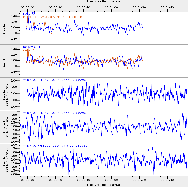
BIM Morne Bigot, Anses d'Arlets, Martinique - Earthquake Result Viewer
*The percent match for this event was below the threshold and hence no stack was calculated.
| Earthquake location: |
Easter Island Region |
| Earthquake latitude/longitude: |
-23.0/-114.3 |
| Earthquake time(UTC): |
2014/02/14 (045) 07:44:15 GMT |
| Earthquake Depth: |
12 km |
| Earthquake Magnitude: |
5.6 MWW, 5.5 MWB, 5.6 MWC |
| Earthquake Catalog/Contributor: |
NEIC PDE/NEIC COMCAT |
|
| Network: |
WI West Indies IPGP Network |
| Station: |
BIM Morne Bigot, Anses d'Arlets, Martinique |
| Lat/Lon: |
14.52 N/61.07 W |
| Elevation: |
391 m |
|
| Distance: |
64.1 deg |
| Az: |
59.661 deg |
| Baz: |
235.226 deg |
| Ray Param: |
$rayparam |
*The percent match for this event was below the threshold and hence was not used in the summary stack. |
|
| Radial Match: |
47.854786 % |
| Radial Bump: |
400 |
| Transverse Match: |
48.923325 % |
| Transverse Bump: |
400 |
| SOD ConfigId: |
626651 |
| Insert Time: |
2014-04-20 18:14:10.618 +0000 |
| GWidth: |
2.5 |
| Max Bumps: |
400 |
| Tol: |
0.001 |
|
Signal To Noise
| Channel | StoN | STA | LTA |
| WI:BIM:00:HHZ:20140214T07:54:17.53998Z | 2.4422905 | 1.1657606E-6 | 4.7732266E-7 |
| WI:BIM:00:HHN:20140214T07:54:17.53998Z | 0.8917604 | 6.034164E-7 | 6.766576E-7 |
| WI:BIM:00:HHE:20140214T07:54:17.53998Z | 1.4870346 | 7.390513E-7 | 4.9699673E-7 |
| Arrivals |
| Ps | |
| PpPs | |
| PsPs/PpSs | |


