You are here: Home > Network List > II - Global Seismograph Network (GSN - IRIS/IDA) Stations List
> Station WRAB Tennant Creek, NT, Australia > Earthquake Result Viewer
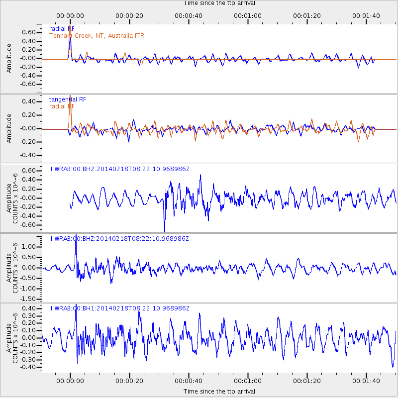
WRAB Tennant Creek, NT, Australia - Earthquake Result Viewer
*The percent match for this event was below the threshold and hence no stack was calculated.
| Earthquake location: |
South Of Kermadec Islands |
| Earthquake latitude/longitude: |
-34.8/-179.4 |
| Earthquake time(UTC): |
2014/02/18 (049) 08:14:42 GMT |
| Earthquake Depth: |
27 km |
| Earthquake Magnitude: |
5.6 MWC, 5.6 MWC |
| Earthquake Catalog/Contributor: |
NEIC PDE/NEIC COMCAT |
|
| Network: |
II Global Seismograph Network (GSN - IRIS/IDA) |
| Station: |
WRAB Tennant Creek, NT, Australia |
| Lat/Lon: |
19.93 S/134.36 E |
| Elevation: |
366 m |
|
| Distance: |
43.3 deg |
| Az: |
277.62 deg |
| Baz: |
119.888 deg |
| Ray Param: |
$rayparam |
*The percent match for this event was below the threshold and hence was not used in the summary stack. |
|
| Radial Match: |
56.54605 % |
| Radial Bump: |
400 |
| Transverse Match: |
50.707104 % |
| Transverse Bump: |
400 |
| SOD ConfigId: |
626651 |
| Insert Time: |
2014-04-20 18:34:06.261 +0000 |
| GWidth: |
2.5 |
| Max Bumps: |
400 |
| Tol: |
0.001 |
|
Signal To Noise
| Channel | StoN | STA | LTA |
| II:WRAB:00:BHZ:20140218T08:22:10.968986Z | 4.2492766 | 4.567533E-7 | 1.07489655E-7 |
| II:WRAB:00:BH1:20140218T08:22:10.968986Z | 1.7178175 | 1.5938953E-7 | 9.278607E-8 |
| II:WRAB:00:BH2:20140218T08:22:10.968986Z | 1.9537667 | 2.2960317E-7 | 1.1751821E-7 |
| Arrivals |
| Ps | |
| PpPs | |
| PsPs/PpSs | |


