You are here: Home > Network List > TA - USArray Transportable Network (new EarthScope stations) Stations List
> Station G03D McMinnville, OR, USA > Earthquake Result Viewer
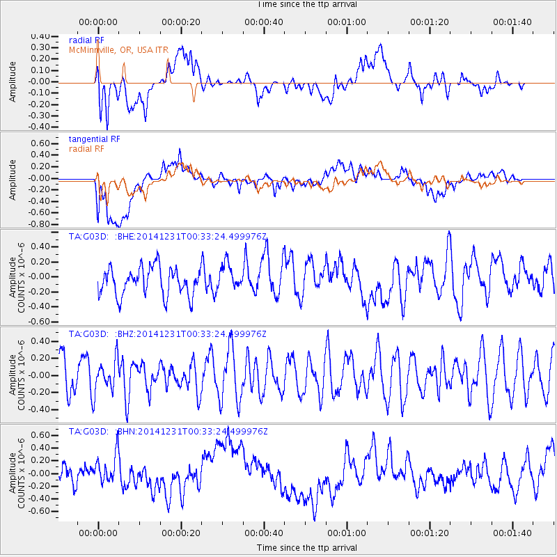
G03D McMinnville, OR, USA - Earthquake Result Viewer
*The percent match for this event was below the threshold and hence no stack was calculated.
| Earthquake location: |
South Of Mariana Islands |
| Earthquake latitude/longitude: |
13.8/146.2 |
| Earthquake time(UTC): |
2014/12/31 (365) 00:21:48 GMT |
| Earthquake Depth: |
60 km |
| Earthquake Magnitude: |
5.1 mb |
| Earthquake Catalog/Contributor: |
ISC/ISC |
|
| Network: |
TA USArray Transportable Network (new EarthScope stations) |
| Station: |
G03D McMinnville, OR, USA |
| Lat/Lon: |
45.21 N/123.26 W |
| Elevation: |
222 m |
|
| Distance: |
80.7 deg |
| Az: |
45.747 deg |
| Baz: |
280.114 deg |
| Ray Param: |
$rayparam |
*The percent match for this event was below the threshold and hence was not used in the summary stack. |
|
| Radial Match: |
41.215645 % |
| Radial Bump: |
400 |
| Transverse Match: |
43.485302 % |
| Transverse Bump: |
400 |
| SOD ConfigId: |
3390531 |
| Insert Time: |
2019-04-15 21:23:58.586 +0000 |
| GWidth: |
2.5 |
| Max Bumps: |
400 |
| Tol: |
0.001 |
|
Signal To Noise
| Channel | StoN | STA | LTA |
| TA:G03D: :BHZ:20141231T00:33:24.499976Z | 1.0522875 | 1.7420493E-7 | 1.6554881E-7 |
| TA:G03D: :BHN:20141231T00:33:24.499976Z | 1.3653964 | 2.6389736E-7 | 1.9327528E-7 |
| TA:G03D: :BHE:20141231T00:33:24.499976Z | 0.92642826 | 1.7236275E-7 | 1.8605083E-7 |
| Arrivals |
| Ps | |
| PpPs | |
| PsPs/PpSs | |


