You are here: Home > Network List > UW - Pacific Northwest Regional Seismic Network Stations List
> Station MRBL Marblemount, WA, USA > Earthquake Result Viewer
MRBL Marblemount, WA, USA - Earthquake Result Viewer
*The percent match for this event was below the threshold and hence no stack was calculated.
| Earthquake location: |
South Of Kermadec Islands |
| Earthquake latitude/longitude: |
-34.8/-179.4 |
| Earthquake time(UTC): |
2014/02/18 (049) 08:14:42 GMT |
| Earthquake Depth: |
27 km |
| Earthquake Magnitude: |
5.6 MWC, 5.6 MWC |
| Earthquake Catalog/Contributor: |
NEIC PDE/NEIC COMCAT |
|
| Network: |
UW Pacific Northwest Regional Seismic Network |
| Station: |
MRBL Marblemount, WA, USA |
| Lat/Lon: |
48.52 N/121.48 W |
| Elevation: |
75 m |
|
| Distance: |
97.7 deg |
| Az: |
34.649 deg |
| Baz: |
224.727 deg |
| Ray Param: |
$rayparam |
*The percent match for this event was below the threshold and hence was not used in the summary stack. |
|
| Radial Match: |
52.42841 % |
| Radial Bump: |
400 |
| Transverse Match: |
49.998238 % |
| Transverse Bump: |
400 |
| SOD ConfigId: |
626651 |
| Insert Time: |
2014-04-20 18:39:16.819 +0000 |
| GWidth: |
2.5 |
| Max Bumps: |
400 |
| Tol: |
0.001 |
|
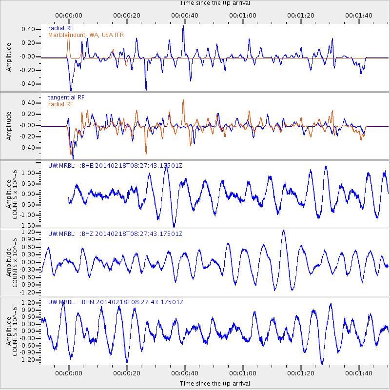
Signal To Noise
| Channel | StoN | STA | LTA |
| UW:MRBL: :BHZ:20140218T08:27:43.17501Z | 0.7562996 | 2.3919048E-7 | 3.162642E-7 |
| UW:MRBL: :BHN:20140218T08:27:43.17501Z | 1.551319 | 6.7144026E-7 | 4.3281892E-7 |
| UW:MRBL: :BHE:20140218T08:27:43.17501Z | 3.7133198 | 8.434944E-7 | 2.2715372E-7 |
| Arrivals |
| Ps | |
| PpPs | |
| PsPs/PpSs | |


