You are here: Home > Network List > TA - USArray Transportable Network (new EarthScope stations) Stations List
> Station J01E Myrtle Point, OR, USA > Earthquake Result Viewer
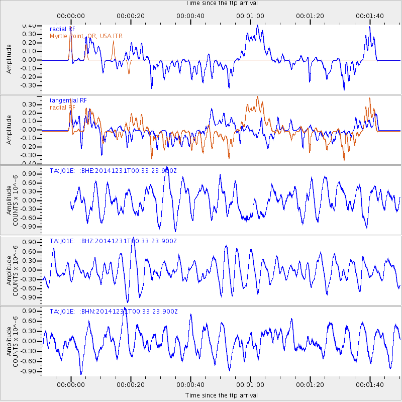
J01E Myrtle Point, OR, USA - Earthquake Result Viewer
*The percent match for this event was below the threshold and hence no stack was calculated.
| Earthquake location: |
South Of Mariana Islands |
| Earthquake latitude/longitude: |
13.8/146.2 |
| Earthquake time(UTC): |
2014/12/31 (365) 00:21:48 GMT |
| Earthquake Depth: |
60 km |
| Earthquake Magnitude: |
5.1 mb |
| Earthquake Catalog/Contributor: |
ISC/ISC |
|
| Network: |
TA USArray Transportable Network (new EarthScope stations) |
| Station: |
J01E Myrtle Point, OR, USA |
| Lat/Lon: |
43.16 N/123.93 W |
| Elevation: |
128 m |
|
| Distance: |
80.6 deg |
| Az: |
47.877 deg |
| Baz: |
279.997 deg |
| Ray Param: |
$rayparam |
*The percent match for this event was below the threshold and hence was not used in the summary stack. |
|
| Radial Match: |
47.044746 % |
| Radial Bump: |
400 |
| Transverse Match: |
59.70945 % |
| Transverse Bump: |
400 |
| SOD ConfigId: |
3390531 |
| Insert Time: |
2019-04-15 21:24:00.028 +0000 |
| GWidth: |
2.5 |
| Max Bumps: |
400 |
| Tol: |
0.001 |
|
Signal To Noise
| Channel | StoN | STA | LTA |
| TA:J01E: :BHZ:20141231T00:33:23.900Z | 0.536842 | 1.9956867E-7 | 3.7174567E-7 |
| TA:J01E: :BHN:20141231T00:33:23.900Z | 1.5614089 | 4.4710345E-7 | 2.8634616E-7 |
| TA:J01E: :BHE:20141231T00:33:23.900Z | 2.2138517 | 7.438359E-7 | 3.3599173E-7 |
| Arrivals |
| Ps | |
| PpPs | |
| PsPs/PpSs | |


