You are here: Home > Network List > AE - Arizona Broadband Seismic Network Stations List
> Station X18A Snowflake, AZ, USA > Earthquake Result Viewer
X18A Snowflake, AZ, USA - Earthquake Result Viewer
| Earthquake location: |
North Atlantic Ocean |
| Earthquake latitude/longitude: |
14.7/-58.9 |
| Earthquake time(UTC): |
2014/02/18 (049) 09:27:13 GMT |
| Earthquake Depth: |
17 km |
| Earthquake Magnitude: |
6.5 MWW, 6.3 MWB, 6.5 MWC, 6.6 MWC, 6.7 MI |
| Earthquake Catalog/Contributor: |
NEIC PDE/NEIC COMCAT |
|
| Network: |
AE Arizona Broadband Seismic Network |
| Station: |
X18A Snowflake, AZ, USA |
| Lat/Lon: |
34.53 N/109.95 W |
| Elevation: |
1751 m |
|
| Distance: |
49.9 deg |
| Az: |
302.925 deg |
| Baz: |
100.248 deg |
| Ray Param: |
0.06840731 |
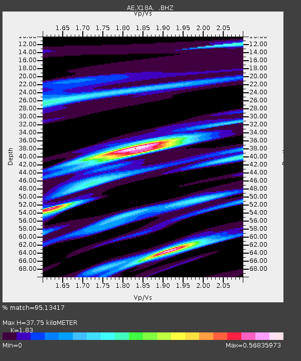
| Estimated Moho Depth: |
37.75 km |
| Estimated Crust Vp/Vs: |
1.83 |
| Assumed Crust Vp: |
6.496 km/s |
| Estimated Crust Vs: |
3.55 km/s |
| Estimated Crust Poisson's Ratio: |
0.29 |
|
| Radial Match: |
95.13417 % |
| Radial Bump: |
319 |
| Transverse Match: |
73.01757 % |
| Transverse Bump: |
400 |
| SOD ConfigId: |
626651 |
| Insert Time: |
2014-04-20 18:40:19.843 +0000 |
| GWidth: |
2.5 |
| Max Bumps: |
400 |
| Tol: |
0.001 |
|

Signal To Noise
| Channel | StoN | STA | LTA |
| AE:X18A: :BHZ:20140218T09:35:34.749994Z | 4.6887484 | 1.2160716E-6 | 2.5935952E-7 |
| AE:X18A: :BHN:20140218T09:35:34.749994Z | 1.3882074 | 2.6014396E-7 | 1.873956E-7 |
| AE:X18A: :BHE:20140218T09:35:34.749994Z | 2.6445336 | 5.411201E-7 | 2.0461835E-7 |
| Arrivals |
| Ps | 5.1 SECOND |
| PpPs | 16 SECOND |
| PsPs/PpSs | 21 SECOND |


