You are here: Home > Network List > AG - Arkansas Seismic Network Stations List
> Station LCAR Lake Charles,AR > Earthquake Result Viewer
LCAR Lake Charles,AR - Earthquake Result Viewer
| Earthquake location: |
North Atlantic Ocean |
| Earthquake latitude/longitude: |
14.7/-58.9 |
| Earthquake time(UTC): |
2014/02/18 (049) 09:27:13 GMT |
| Earthquake Depth: |
17 km |
| Earthquake Magnitude: |
6.5 MWW, 6.3 MWB, 6.5 MWC, 6.6 MWC, 6.7 MI |
| Earthquake Catalog/Contributor: |
NEIC PDE/NEIC COMCAT |
|
| Network: |
AG Arkansas Seismic Network |
| Station: |
LCAR Lake Charles,AR |
| Lat/Lon: |
36.07 N/91.15 W |
| Elevation: |
103 m |
|
| Distance: |
35.8 deg |
| Az: |
312.445 deg |
| Baz: |
118.166 deg |
| Ray Param: |
0.07699284 |
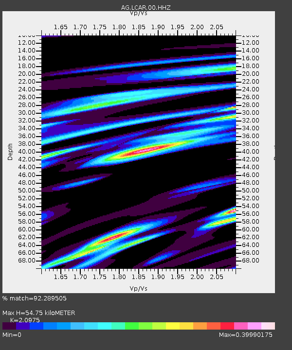
| Estimated Moho Depth: |
54.75 km |
| Estimated Crust Vp/Vs: |
2.10 |
| Assumed Crust Vp: |
6.53 km/s |
| Estimated Crust Vs: |
3.113 km/s |
| Estimated Crust Poisson's Ratio: |
0.35 |
|
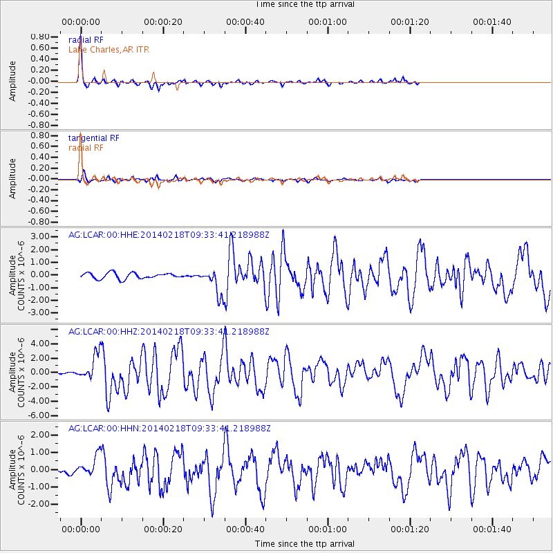
| Radial Match: |
92.289505 % |
| Radial Bump: |
161 |
| Transverse Match: |
81.329384 % |
| Transverse Bump: |
400 |
| SOD ConfigId: |
626651 |
| Insert Time: |
2014-04-20 18:40:48.771 +0000 |
| GWidth: |
2.5 |
| Max Bumps: |
400 |
| Tol: |
0.001 |
|
Signal To Noise
| Channel | StoN | STA | LTA |
| AG:LCAR:00:HHZ:20140218T09:33:41.218988Z | 14.093967 | 1.855475E-6 | 1.316503E-7 |
| AG:LCAR:00:HHN:20140218T09:33:41.218988Z | 2.6878526 | 6.297834E-7 | 2.3430727E-7 |
| AG:LCAR:00:HHE:20140218T09:33:41.218988Z | 4.7602077 | 1.0934169E-6 | 2.2969944E-7 |
| Arrivals |
| Ps | 9.8 SECOND |
| PpPs | 24 SECOND |
| PsPs/PpSs | 34 SECOND |


