You are here: Home > Network List > AG - Arkansas Seismic Network Stations List
> Station WHAR Woolly Hollow State Park,AR > Earthquake Result Viewer
WHAR Woolly Hollow State Park,AR - Earthquake Result Viewer
| Earthquake location: |
North Atlantic Ocean |
| Earthquake latitude/longitude: |
14.7/-58.9 |
| Earthquake time(UTC): |
2014/02/18 (049) 09:27:13 GMT |
| Earthquake Depth: |
17 km |
| Earthquake Magnitude: |
6.5 MWW, 6.3 MWB, 6.5 MWC, 6.6 MWC, 6.7 MI |
| Earthquake Catalog/Contributor: |
NEIC PDE/NEIC COMCAT |
|
| Network: |
AG Arkansas Seismic Network |
| Station: |
WHAR Woolly Hollow State Park,AR |
| Lat/Lon: |
35.29 N/92.29 W |
| Elevation: |
184 m |
|
| Distance: |
36.3 deg |
| Az: |
310.554 deg |
| Baz: |
115.978 deg |
| Ray Param: |
0.076737605 |
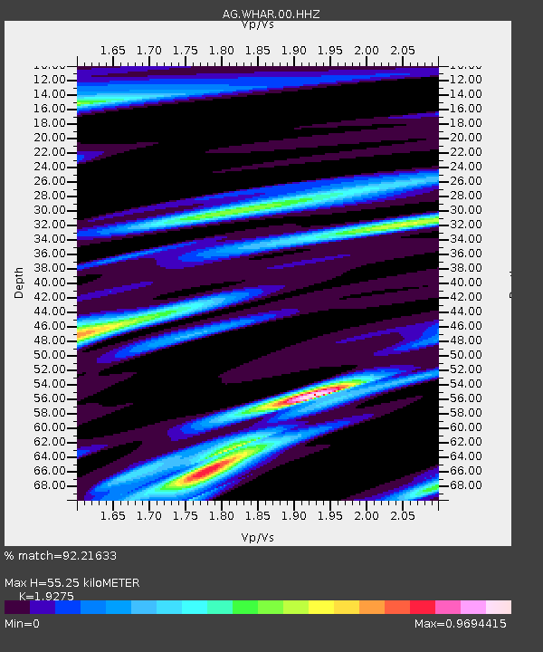
| Estimated Moho Depth: |
55.25 km |
| Estimated Crust Vp/Vs: |
1.93 |
| Assumed Crust Vp: |
6.498 km/s |
| Estimated Crust Vs: |
3.371 km/s |
| Estimated Crust Poisson's Ratio: |
0.32 |
|
| Radial Match: |
92.21633 % |
| Radial Bump: |
253 |
| Transverse Match: |
85.757805 % |
| Transverse Bump: |
372 |
| SOD ConfigId: |
626651 |
| Insert Time: |
2014-04-20 18:40:49.864 +0000 |
| GWidth: |
2.5 |
| Max Bumps: |
400 |
| Tol: |
0.001 |
|

Signal To Noise
| Channel | StoN | STA | LTA |
| AG:WHAR:00:HHZ:20140218T09:33:45.214014Z | 18.016306 | 2.6162259E-6 | 1.4521432E-7 |
| AG:WHAR:00:HHN:20140218T09:33:45.214014Z | 1.796963 | 5.8724464E-7 | 3.2679839E-7 |
| AG:WHAR:00:HHE:20140218T09:33:45.214014Z | 5.2247095 | 1.1862559E-6 | 2.2704725E-7 |
| Arrivals |
| Ps | 8.5 SECOND |
| PpPs | 23 SECOND |
| PsPs/PpSs | 32 SECOND |


