You are here: Home > Network List > AG - Arkansas Seismic Network Stations List
> Station WLAR White Oak Lake,AR > Earthquake Result Viewer
WLAR White Oak Lake,AR - Earthquake Result Viewer
| Earthquake location: |
North Atlantic Ocean |
| Earthquake latitude/longitude: |
14.7/-58.9 |
| Earthquake time(UTC): |
2014/02/18 (049) 09:27:13 GMT |
| Earthquake Depth: |
17 km |
| Earthquake Magnitude: |
6.5 MWW, 6.3 MWB, 6.5 MWC, 6.6 MWC, 6.7 MI |
| Earthquake Catalog/Contributor: |
NEIC PDE/NEIC COMCAT |
|
| Network: |
AG Arkansas Seismic Network |
| Station: |
WLAR White Oak Lake,AR |
| Lat/Lon: |
33.69 N/93.11 W |
| Elevation: |
77 m |
|
| Distance: |
36.3 deg |
| Az: |
307.62 deg |
| Baz: |
113.149 deg |
| Ray Param: |
0.07676268 |
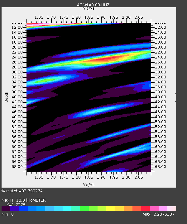
| Estimated Moho Depth: |
10.0 km |
| Estimated Crust Vp/Vs: |
1.78 |
| Assumed Crust Vp: |
6.245 km/s |
| Estimated Crust Vs: |
3.513 km/s |
| Estimated Crust Poisson's Ratio: |
0.27 |
|
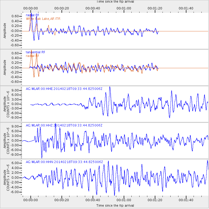
| Radial Match: |
87.799774 % |
| Radial Bump: |
311 |
| Transverse Match: |
81.34072 % |
| Transverse Bump: |
386 |
| SOD ConfigId: |
626651 |
| Insert Time: |
2014-04-20 18:40:57.491 +0000 |
| GWidth: |
2.5 |
| Max Bumps: |
400 |
| Tol: |
0.001 |
|
Signal To Noise
| Channel | StoN | STA | LTA |
| AG:WLAR:00:HHZ:20140218T09:33:44.825006Z | 10.619246 | 2.2995034E-6 | 2.1654112E-7 |
| AG:WLAR:00:HHN:20140218T09:33:44.825006Z | 2.023093 | 5.185192E-7 | 2.563002E-7 |
| AG:WLAR:00:HHE:20140218T09:33:44.825006Z | 1.6356897 | 5.7934074E-7 | 3.5418742E-7 |
| Arrivals |
| Ps | 1.3 SECOND |
| PpPs | 4.1 SECOND |
| PsPs/PpSs | 5.5 SECOND |


