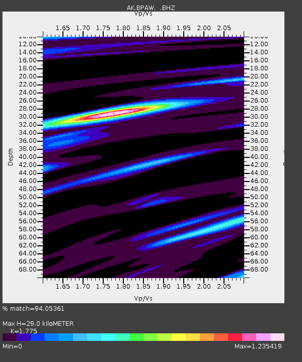
BPAW Bear Paw Mountain Broadband - Earthquake Result Viewer

Earthquake location: North Atlantic Ocean
Earthquake latitude/longitude: 14.7/-58.9
Earthquake time(UTC): 2014/02/18 (049) 09:27:13 GMT
Earthquake Depth: 17 km
Earthquake Magnitude: 6.5 MWW, 6.3 MWB, 6.5 MWC, 6.6 MWC, 6.7 MI
Earthquake Catalog/Contributor: NEIC PDE/NEIC COMCAT
Network: AK Alaska Regional Network
Station: BPAW Bear Paw Mountain Broadband
Lat/Lon: 64.10 N/150.98 W
Elevation: 619 m
Distance: 77.8 deg
Az: 333.323 deg
Baz: 81.673 deg
Ray Param: 0.050032947
Estimated Moho Depth: 29.0 km
Estimated Crust Vp/Vs: 1.77
Assumed Crust Vp: 6.566 km/s
Estimated Crust Vs: 3.699 km/s
Estimated Crust Poisson's Ratio: 0.27
Radial Match: 94.05361 %
Radial Bump: 345
Transverse Match: 79.83925 %
Transverse Bump: 400
SOD ConfigId: 626651
Insert Time: 2014-04-20 18:41:12.963 +0000
GWidth: 2.5
Max Bumps: 400
Tol: 0.001

Signal To Noise

ChannelStoNSTALTA
AK:BPAW: :BHZ:20140218T09:38:38.527979Z15.1834292.5041873E-61.6492898E-7
AK:BPAW: :BHN:20140218T09:38:38.527979Z1.45229673.0637003E-72.1095552E-7
AK:BPAW: :BHE:20140218T09:38:38.527979Z6.18246849.769923E-71.5802624E-7
Arrivals
Ps3.5 SECOND
PpPs12 SECOND
PsPs/PpSs15 SECOND