You are here: Home > Network List > AZ - ANZA Regional Network Stations List
> Station IWR Idyllwild Water Reclamation, Idyllwild, CA, USA > Earthquake Result Viewer
IWR Idyllwild Water Reclamation, Idyllwild, CA, USA - Earthquake Result Viewer
| Earthquake location: |
North Atlantic Ocean |
| Earthquake latitude/longitude: |
14.7/-58.9 |
| Earthquake time(UTC): |
2014/02/18 (049) 09:27:13 GMT |
| Earthquake Depth: |
17 km |
| Earthquake Magnitude: |
6.5 MWW, 6.3 MWB, 6.5 MWC, 6.6 MWC, 6.7 MI |
| Earthquake Catalog/Contributor: |
NEIC PDE/NEIC COMCAT |
|
| Network: |
AZ ANZA Regional Network |
| Station: |
IWR Idyllwild Water Reclamation, Idyllwild, CA, USA |
| Lat/Lon: |
33.73 N/116.77 W |
| Elevation: |
1464 m |
|
| Distance: |
55.4 deg |
| Az: |
300.973 deg |
| Baz: |
95.251 deg |
| Ray Param: |
0.06482239 |
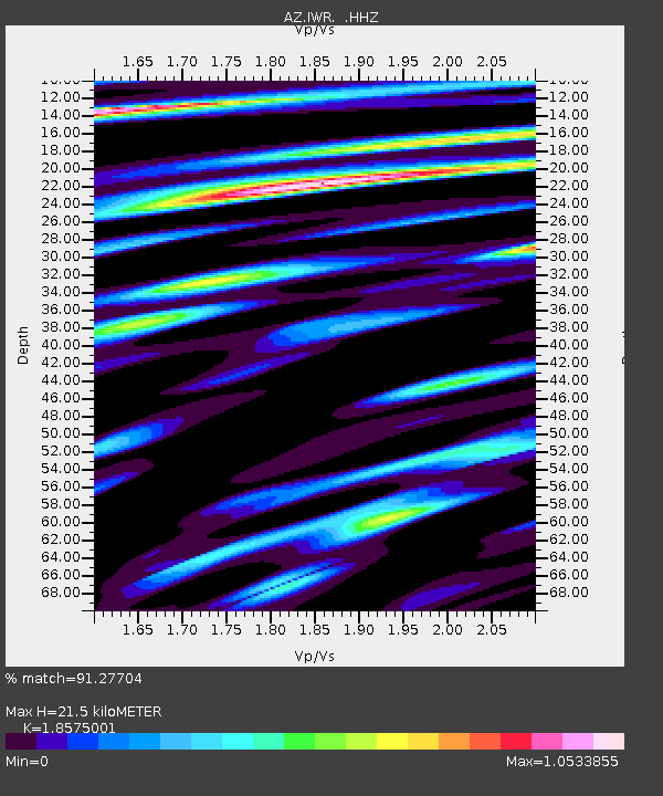
| Estimated Moho Depth: |
21.5 km |
| Estimated Crust Vp/Vs: |
1.86 |
| Assumed Crust Vp: |
6.264 km/s |
| Estimated Crust Vs: |
3.372 km/s |
| Estimated Crust Poisson's Ratio: |
0.30 |
|
| Radial Match: |
91.27704 % |
| Radial Bump: |
325 |
| Transverse Match: |
94.49348 % |
| Transverse Bump: |
259 |
| SOD ConfigId: |
626651 |
| Insert Time: |
2014-04-20 18:46:04.058 +0000 |
| GWidth: |
2.5 |
| Max Bumps: |
400 |
| Tol: |
0.001 |
|

Signal To Noise
| Channel | StoN | STA | LTA |
| AZ:IWR: :HHZ:20140218T09:36:15.339014Z | 3.055776 | 7.407786E-7 | 2.4241916E-7 |
| AZ:IWR: :HHN:20140218T09:36:15.339014Z | 1.8120322 | 3.783095E-7 | 2.0877637E-7 |
| AZ:IWR: :HHE:20140218T09:36:15.339014Z | 3.281251 | 5.129126E-7 | 1.5631618E-7 |
| Arrivals |
| Ps | 3.1 SECOND |
| PpPs | 9.4 SECOND |
| PsPs/PpSs | 12 SECOND |


