You are here: Home > Network List > CN - Canadian National Seismograph Network Stations List
> Station KGNO KINGSTON, ON > Earthquake Result Viewer
KGNO KINGSTON, ON - Earthquake Result Viewer
| Earthquake location: |
North Atlantic Ocean |
| Earthquake latitude/longitude: |
14.7/-58.9 |
| Earthquake time(UTC): |
2014/02/18 (049) 09:27:13 GMT |
| Earthquake Depth: |
17 km |
| Earthquake Magnitude: |
6.5 MWW, 6.3 MWB, 6.5 MWC, 6.6 MWC, 6.7 MI |
| Earthquake Catalog/Contributor: |
NEIC PDE/NEIC COMCAT |
|
| Network: |
CN Canadian National Seismograph Network |
| Station: |
KGNO KINGSTON, ON |
| Lat/Lon: |
44.23 N/76.49 W |
| Elevation: |
89 m |
|
| Distance: |
33.1 deg |
| Az: |
336.566 deg |
| Baz: |
147.627 deg |
| Ray Param: |
0.07836811 |
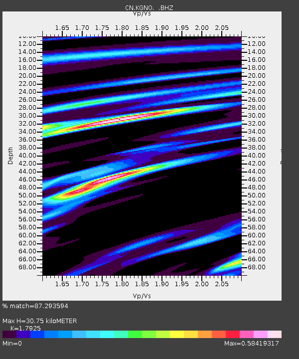
| Estimated Moho Depth: |
30.75 km |
| Estimated Crust Vp/Vs: |
1.79 |
| Assumed Crust Vp: |
6.577 km/s |
| Estimated Crust Vs: |
3.669 km/s |
| Estimated Crust Poisson's Ratio: |
0.27 |
|
| Radial Match: |
87.293594 % |
| Radial Bump: |
330 |
| Transverse Match: |
73.646355 % |
| Transverse Bump: |
400 |
| SOD ConfigId: |
626651 |
| Insert Time: |
2014-04-20 18:50:21.716 +0000 |
| GWidth: |
2.5 |
| Max Bumps: |
400 |
| Tol: |
0.001 |
|

Signal To Noise
| Channel | StoN | STA | LTA |
| CN:KGNO: :BHZ:20140218T09:33:17.274988Z | 7.6654735 | 2.092576E-6 | 2.7298722E-7 |
| CN:KGNO: :BHN:20140218T09:33:17.274988Z | 4.8124185 | 1.036353E-6 | 2.1534973E-7 |
| CN:KGNO: :BHE:20140218T09:33:17.274988Z | 3.4098296 | 7.5333526E-7 | 2.2093046E-7 |
| Arrivals |
| Ps | 4.0 SECOND |
| PpPs | 12 SECOND |
| PsPs/PpSs | 16 SECOND |


