You are here: Home > Network List > CI - Caltech Regional Seismic Network Stations List
> Station CIA CIA, Avalon Catalina Island, CA, USA > Earthquake Result Viewer
CIA CIA, Avalon Catalina Island, CA, USA - Earthquake Result Viewer
| Earthquake location: |
Fiji Islands Region |
| Earthquake latitude/longitude: |
-20.6/-177.7 |
| Earthquake time(UTC): |
2003/01/04 (004) 05:15:03 GMT |
| Earthquake Depth: |
378 km |
| Earthquake Magnitude: |
6.0 MB, 6.5 MW, 6.5 MW |
| Earthquake Catalog/Contributor: |
WHDF/NEIC |
|
| Network: |
CI Caltech Regional Seismic Network |
| Station: |
CIA CIA, Avalon Catalina Island, CA, USA |
| Lat/Lon: |
33.40 N/118.41 W |
| Elevation: |
467 m |
|
| Distance: |
77.9 deg |
| Az: |
47.324 deg |
| Baz: |
235.438 deg |
| Ray Param: |
0.04893534 |
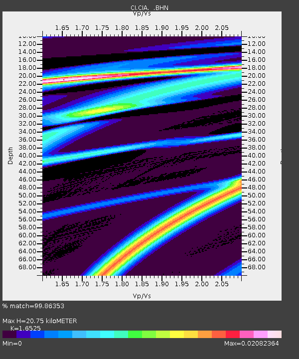
| Estimated Moho Depth: |
20.75 km |
| Estimated Crust Vp/Vs: |
1.65 |
| Assumed Crust Vp: |
6.048 km/s |
| Estimated Crust Vs: |
3.66 km/s |
| Estimated Crust Poisson's Ratio: |
0.21 |
|
| Radial Match: |
99.86353 % |
| Radial Bump: |
10 |
| Transverse Match: |
89.01655 % |
| Transverse Bump: |
95 |
| SOD ConfigId: |
3770 |
| Insert Time: |
2010-02-25 20:56:14.796 +0000 |
| GWidth: |
2.5 |
| Max Bumps: |
400 |
| Tol: |
0.001 |
|
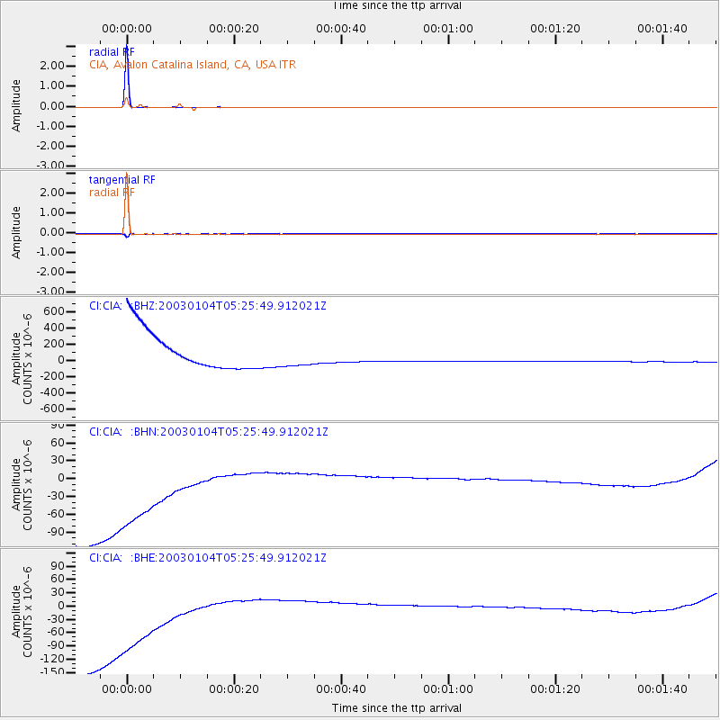
Signal To Noise
| Channel | StoN | STA | LTA |
| CI:CIA: :BHN:20030104T05:25:49.912021Z | 0.72036994 | 2.3355866E-4 | 3.2422045E-4 |
| CI:CIA: :BHE:20030104T05:25:49.912021Z | 0.68643385 | 2.9189192E-4 | 4.252295E-4 |
| CI:CIA: :BHZ:20030104T05:25:49.912021Z | 0.66740763 | 1.6247528E-4 | 2.4344234E-4 |
| Arrivals |
| Ps | 2.3 SECOND |
| PpPs | 8.9 SECOND |
| PsPs/PpSs | 11 SECOND |


