You are here: Home > Network List > GH - Ghana Digital Seismic Network Stations List
> Station KLEF Ho, Ghana > Earthquake Result Viewer
KLEF Ho, Ghana - Earthquake Result Viewer
| Earthquake location: |
North Atlantic Ocean |
| Earthquake latitude/longitude: |
14.7/-58.9 |
| Earthquake time(UTC): |
2014/02/18 (049) 09:27:13 GMT |
| Earthquake Depth: |
17 km |
| Earthquake Magnitude: |
6.5 MWW, 6.3 MWB, 6.5 MWC, 6.6 MWC, 6.7 MI |
| Earthquake Catalog/Contributor: |
NEIC PDE/NEIC COMCAT |
|
| Network: |
GH Ghana Digital Seismic Network |
| Station: |
KLEF Ho, Ghana |
| Lat/Lon: |
6.61 N/0.44 E |
| Elevation: |
313 m |
|
| Distance: |
58.8 deg |
| Az: |
91.103 deg |
| Baz: |
283.064 deg |
| Ray Param: |
0.06262046 |
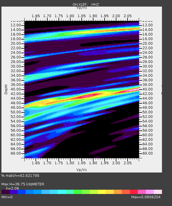
| Estimated Moho Depth: |
39.75 km |
| Estimated Crust Vp/Vs: |
2.09 |
| Assumed Crust Vp: |
6.612 km/s |
| Estimated Crust Vs: |
3.164 km/s |
| Estimated Crust Poisson's Ratio: |
0.35 |
|
| Radial Match: |
82.821785 % |
| Radial Bump: |
400 |
| Transverse Match: |
53.686153 % |
| Transverse Bump: |
400 |
| SOD ConfigId: |
626651 |
| Insert Time: |
2014-04-20 18:54:01.446 +0000 |
| GWidth: |
2.5 |
| Max Bumps: |
400 |
| Tol: |
0.001 |
|

Signal To Noise
| Channel | StoN | STA | LTA |
| GH:KLEF: :HHZ:20140218T09:36:39.300012Z | 12.975284 | 2.7714116E-6 | 2.1359159E-7 |
| GH:KLEF: :HHN:20140218T09:36:39.300012Z | 1.0928161 | 3.8598662E-7 | 3.5320363E-7 |
| GH:KLEF: :HHE:20140218T09:36:39.300012Z | 2.039794 | 1.5879061E-6 | 7.7846397E-7 |
| Arrivals |
| Ps | 6.8 SECOND |
| PpPs | 18 SECOND |
| PsPs/PpSs | 25 SECOND |


